Aurukun geodata
Aurukun (Queensland) is a populated locality; located in Australia in Australia/Brisbane (GMT+10) time zone. With population of 1,282 people, there are 3487 cities with bigger population in this country. Compared to other cities in Australia, 98.3% of cities are located further ↓South; 75.1% of cities are located further →East and 76.1% of cities have higher elevation than Aurukun. Note1


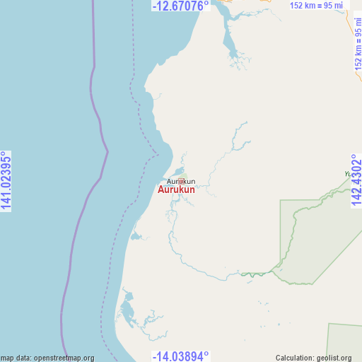
Aurukun GPS coordinates[2]
13° 21' 20.952" South, 141° 43' 37.452" East
| Map corner | latitude | longitude |
|---|---|---|
| Upper-left | -12.67076°, | 141.02395° |
| Center: | -13.35582°, | 141.72707° |
| Lower-right: | -14.03894°, | 142.4302° |
| Map W x H: | 152.1×152.1 km | = 94.5×94.5mi |
| max Lat: | -10.58257° ⇑1.7% North |
| Aurukun: | -13.35582° |
| min Lat: | ⇓98.3% South -43.31423° |
| min Long | Aurukun | max Long |
| 113.53327° | 141.72707° | 153.61246° |
| W 24.9%⇐ | ⇒75.1% E |
Elevation
Elevation of Aurukun is 18 m = 59 ft, and this is 104 m = 341 ft below average elevation for this country.
| Max E: |
1715 m = 5627 ft | 76.1% |
| Avg. | 122 m = 400 ft | |
| Aurukun | 18 m = 59 ft | |
Min E: |
-2 m = -7 ft | 23.9% |
See also: Australia elevation on elevation.city.
Geographical zone
Aurukun is located in South Torrid zone (between Equator and Tropic of Capricorn). Distance of this Southern Tropic circle is 1120.9 km =696.5 mi to South.| Distance of | km | miles | from Aurukun |
|---|---|---|---|
| Equator | 1485 | 922.7 | to North |
| Tropic Capricorn | 1120.9 | 696.5 | to South |
| Antarctic Circle | 5916.1 | 3676.1 | to South |
| South Pole | 8522 | 5295.3 | to South |


Nearby cities:
14 places around Aurukun: (largest is in red/bold)
• Bamaga
283.3 km =176 mi,  14°
14°
• Hope Vale
423.6 km =263.2 mi,  120°
120°
• Horn
311.6 km =193.6 mi, 11°
• Injinoo
262.2 km =162.9 mi, 12°
• Kowanyama
235.5 km =146.3 mi,  179°
179°
• Laura
358.9 km =223 mi,  132°
132°
• Lockhart River
186.1 km =115.6 mi,  70°
70°
• Mission River
88.2 km =54.8 mi,  16°
16°
• Nanum
80.4 km =50 mi, 10°
• New Mapoon
285.8 km =177.6 mi, 14°
• Pormpuraaw
171.9 km =106.8 mi, 183°
• Thursday Island
313 km =194.5 mi, 9°
• Trunding
81.7 km =50.8 mi, 10°
• Weipa
83.1 km =51.6 mi, 11°
Sources, notices
• [Note1] Compared only with cities in Australia existing in our database
• [Src1] Map data: © OpenStreetMap contributors (CC-BY-SA)
• [Src2] Other city data from geonames.org with taken over terms of usage.
• [Src3] Geographical zone / Annual Mean Temperature by Robert A. Rohde @ Wikipedia
