Armidale geodata
Armidale (New South Wales) is a populated place; located in Australia in Australia/Sydney (GMT+11) time zone. With population of 23,741 people, there are 116 cities with bigger population in this country. Compared to other cities in Australia, 71.5% of cities are located further ↓South; 80% of cities are located further ←West and 99.8% of cities have lower elevation than Armidale. Note1


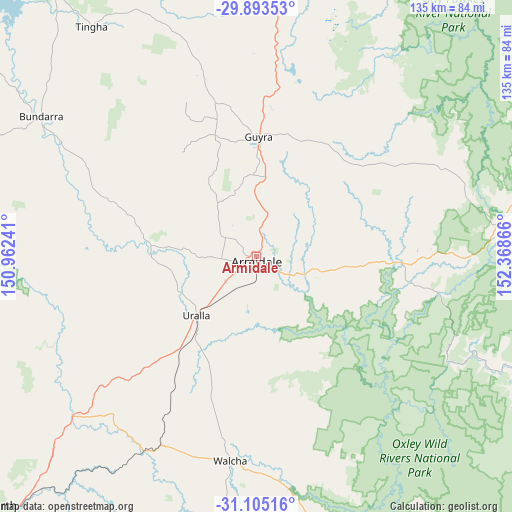
Armidale GPS coordinates[2]
30° 30' 4.428" South, 151° 39' 55.908" East
| Map corner | latitude | longitude |
|---|---|---|
| Upper-left | -29.89353°, | 150.96241° |
| Center: | -30.50123°, | 151.66553° |
| Lower-right: | -31.10516°, | 152.36866° |
| Map W x H: | 134.7×134.7 km | = 83.7×83.7mi |
| max Lat: | -10.58257° ⇑28.5% North |
| Armidale: | -30.50123° |
| min Lat: | ⇓71.5% South -43.31423° |
| min Long | Armidale | max Long |
| 113.53327° | 151.66553° | 153.61246° |
| W 80%⇐ | ⇒20% E |
Elevation
Elevation of Armidale is 1053 m = 3455 ft, and this is 931 m = 3054 ft above average elevation for this country.
| Max E: |
1715 m = 5627 ft | 0.2% |
| Armidale | 1053 m 3455 ft | |
| Avg. | 122 m = 400 ft | |
Min E: |
-2 m = -7 ft | 99.8% |
See also: Australia elevation on elevation.city.
Geographical zone
Armidale is located in South temperate zone (between Tropic of Capricorn and the Antarctic Circle). Distance of this Southern Tropic circle is 785.5 km =488.1 mi to North.| Distance of | km | miles | from Armidale |
|---|---|---|---|
| Equator | 3391.4 | 2107.3 | to North |
| Tropic Capricorn | 785.5 | 488.1 | to North |
| Antarctic Circle | 4009.8 | 2491.6 | to South |
| South Pole | 6615.6 | 4110.7 | to South |


Nearby cities:
15 places around Armidale: (largest is in red/bold)
• Attunga
91.7 km =57 mi,  238°
238°
• Bundarra
67.4 km =41.9 mi,  302°
302°
• Daruka
89.2 km =55.4 mi,  228°
228°
• Gilgai
89.3 km =55.5 mi,  323°
323°
• Glen Innes
85.5 km =53.1 mi,  4°
4°
• Guyra
31.6 km =19.6 mi, 0°
• Hallsville
94.5 km =58.7 mi, 233°
• Invergowrie
15.2 km =9.4 mi,  265°
265°
• Kootingal
85.2 km =52.9 mi,  223°
223°
• Manilla
94.5 km =58.7 mi,  253°
253°
• Moonbi
80.8 km =50.2 mi, 224°
• Moore
90.5 km =56.2 mi, 232°
• Tingha
74.6 km =46.4 mi, 324°
• Uralla
22.2 km =13.8 mi, 225°
• Walcha
54.2 km =33.7 mi,  187°
187°
Sources, notices
• [Note1] Compared only with cities in Australia existing in our database
• [Src1] Map data: © OpenStreetMap contributors (CC-BY-SA)
• [Src2] Other city data from geonames.org with taken over terms of usage.
• [Src3] Geographical zone / Annual Mean Temperature by Robert A. Rohde @ Wikipedia
