South Hedland geodata
South Hedland (Western Australia) is a section of populated place; located in Australia in Australia/Perth (GMT+8) time zone. With population of 10,380 people, there are 551 cities with bigger population in this country. Compared to other cities in Australia, 94.2% of cities are located further ↓South; 89.6% of cities are located further →East and 79% of cities have higher elevation than South Hedland. Note1


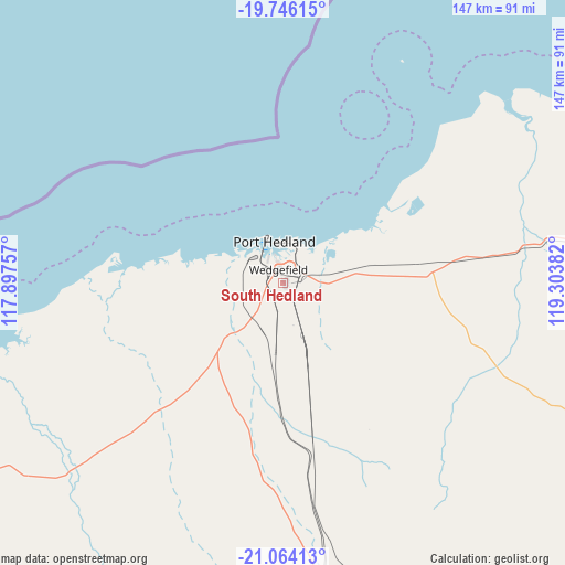
South Hedland GPS coordinates[2]
20° 24' 23.58" South, 118° 36' 2.484" East
| Map corner | latitude | longitude |
|---|---|---|
| Upper-left | -19.74615°, | 117.89757° |
| Center: | -20.40655°, | 118.60069° |
| Lower-right: | -21.06413°, | 119.30382° |
| Map W x H: | 146.5×146.5 km | = 91×91mi |
| max Lat: | -10.58257° ⇑5.8% North |
| South Hedland: | -20.40655° |
| min Lat: | ⇓94.2% South -43.31423° |
| min Long | South Hedland | max Long |
| 113.53327° | 118.60069° | 153.61246° |
| W 10.4%⇐ | ⇒89.6% E |
Elevation
Elevation of South Hedland is 16 m = 52 ft, and this is 106 m = 348 ft below average elevation for this country.
| Max E: |
1715 m = 5627 ft | 79% |
| Avg. | 122 m = 400 ft | |
| South Hedland | 16 m = 52 ft | |
Min E: |
-2 m = -7 ft | 21% |
See also: Australia elevation on elevation.city.
Geographical zone
South Hedland is located in South Torrid zone (between Equator and Tropic of Capricorn). Distance of this Southern Tropic circle is 336.9 km =209.3 mi to South.| Distance of | km | miles | from South Hedland |
|---|---|---|---|
| Equator | 2269 | 1409.9 | to North |
| Tropic Capricorn | 336.9 | 209.3 | to South |
| Antarctic Circle | 5132.2 | 3189 | to South |
| South Pole | 7738.1 | 4808.2 | to South |


Nearby cities:
15 places around South Hedland: (largest is in red/bold)
• Baynton
191.2 km =118.8 mi,  258°
258°
• Bulgarra
185 km =115 mi, 258°
• Dampier
198.7 km =123.5 mi, 261°
• Karratha
186.3 km =115.8 mi, 258°
• Karratha Industrial Estate
184.7 km =114.8 mi, 257°
• Marble Bar
146.1 km =90.8 mi,  125°
125°
• Millars Well
189.3 km =117.6 mi, 258°
• Nickol
191.7 km =119.1 mi, 258°
• Nullagine
227.5 km =141.4 mi,  136°
136°
• Pannawonica
273.3 km =169.8 mi,  239°
239°
• Pegs Creek
187.7 km =116.6 mi, 258°
• Port Hedland
10.5 km =6.5 mi,  5°
5°
• Roebourne
156.7 km =97.4 mi,  254°
254°
• Tom Price
267.7 km =166.3 mi,  198°
198°
• Wickham
155.2 km =96.4 mi, 258°
Sources, notices
• [Note1] Compared only with cities in Australia existing in our database
• [Src1] Map data: © OpenStreetMap contributors (CC-BY-SA)
• [Src2] Other city data from geonames.org with taken over terms of usage.
• [Src3] Geographical zone / Annual Mean Temperature by Robert A. Rohde @ Wikipedia
