Beswick geodata
Beswick (Northern Territory) is a section of populated place; located in Australia in Australia/Darwin (GMT+9.5) time zone. With population of 548 people, there are 4711 cities with bigger population in this country. Compared to other cities in Australia, 98.1% of cities are located further ↓South; 86.8% of cities are located further →East and 77.4% of cities have lower elevation than Beswick. Note1


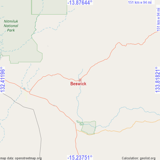
Beswick GPS coordinates[2]
14° 33' 28.872" South, 133° 6' 54.288" East
| Map corner | latitude | longitude |
|---|---|---|
| Upper-left | -13.87644°, | 132.41196° |
| Center: | -14.55802°, | 133.11508° |
| Lower-right: | -15.23751°, | 133.81821° |
| Map W x H: | 151.3×151.3 km | = 94×94mi |
| max Lat: | -10.58257° ⇑1.9% North |
| Beswick: | -14.55802° |
| min Lat: | ⇓98.1% South -43.31423° |
| min Long | Beswick | max Long |
| 113.53327° | 133.11508° | 153.61246° |
| W 13.2%⇐ | ⇒86.8% E |
Elevation
Elevation of Beswick is 151 m = 495 ft, and this is 29 m = 95 ft above average elevation for this country.
| Max E: |
1715 m = 5627 ft | 22.6% |
| Beswick | 151 m 495 ft | |
| Avg. | 122 m = 400 ft | |
Min E: |
-2 m = -7 ft | 77.4% |
See also: Australia elevation on elevation.city.
Geographical zone
Beswick is located in South Torrid zone (between Equator and Tropic of Capricorn). Distance of this Southern Tropic circle is 987.2 km =613.4 mi to South.| Distance of | km | miles | from Beswick |
|---|---|---|---|
| Equator | 1618.7 | 1005.8 | to North |
| Tropic Capricorn | 987.2 | 613.4 | to South |
| Antarctic Circle | 5782.5 | 3593.1 | to South |
| South Pole | 8388.4 | 5212.3 | to South |


Nearby cities:
15 places around Beswick: (largest is in red/bold)
• Cossack
101.9 km =63.3 mi,  276°
276°
• Douglas-Daly
208 km =129.2 mi,  293°
293°
• Gunbalanya
248.4 km =154.3 mi,  358°
358°
• Jabiru
212 km =131.7 mi,  351°
351°
• Kakadu
200.2 km =124.4 mi,  339°
339°
• Katherine
92.2 km =57.3 mi, 276°
• Katherine East
89.9 km =55.9 mi, 276°
• Katherine South
92.7 km =57.6 mi, 276°
• Lansdowne
79.5 km =49.4 mi, 280°
• Marrakai
267.5 km =166.2 mi,  318°
318°
• Mataranka
40.7 km =25.3 mi,  187°
187°
• Miniyeri
127.5 km =79.2 mi,  125°
125°
• Ngukurr
174.9 km =108.7 mi,  96°
96°
• Tindal
79.2 km =49.2 mi,  272°
272°
• West Arnhem
277.8 km =172.6 mi,  21°
21°
Sources, notices
• [Note1] Compared only with cities in Australia existing in our database
• [Src1] Map data: © OpenStreetMap contributors (CC-BY-SA)
• [Src2] Other city data from geonames.org with taken over terms of usage.
• [Src3] Geographical zone / Annual Mean Temperature by Robert A. Rohde @ Wikipedia
