Zangilan geodata
Zangilan (Zǝngilan) is a seat of a first-order administrative division; located in Azerbaijan in Asia/Baku (GMT+4) time zone. With population of 7,483 people, there are 88 cities with bigger population in this country. Compared to other cities in Azerbaijan, 91.9% of cities are located further ↑North; 69.7% of cities are located further →East and 64.3% of cities have lower elevation than Zangilan. Note1


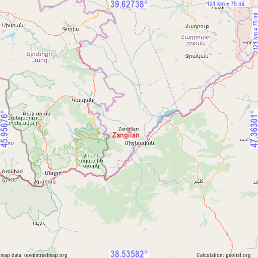
Zangilan GPS coordinates[2]
39° 5' 1.356" North, 46° 39' 35.568" East
| Map corner | latitude | longitude |
|---|---|---|
| Upper-left | 39.62738°, | 45.95676° |
| Center: | 39.08371°, | 46.65988° |
| Lower-right: | 38.53582°, | 47.36301° |
| Map W x H: | 121.4×121.4 km | = 75.4×75.4mi |
| max Lat: | 41.75259° ⇑91.9% North |
| Zangilan: | 39.08371° |
| min Lat: | ⇓8.1% South 38.45598° |
| min Long | Zangilan | max Long |
| 44.84846° | 46.65988° | 50.84003° |
| W 30.3%⇐ | ⇒69.7% E |
Elevation
Elevation of Zangilan is 420 m = 1378 ft, and this is 37 m = 121 ft above average elevation for this country.
| Max E: |
2211 m = 7254 ft | 35.7% |
| Zangilan | 420 m 1378 ft | |
| Avg. | 383 m = 1257 ft | |
Min E: |
-26 m = -85 ft | 64.3% |
See also: Azerbaijan elevation on elevation.city.
Geographical zone
Zangilan is located in North temperate zone (between Tropic of Cancer and the Arctic Circle). Distance of this Northern Tropic circle is 1739.8 km =1081.1 mi to South.| Distance of | km | miles | from Zangilan |
|---|---|---|---|
| North Pole | 5661.4 | 3517.8 | to North |
| Arctic Circle | 3055.5 | 1898.6 | to North |
| Tropic Cancer | 1739.8 | 1081.1 | to South |
| Equator | 4345.7 | 2700.3 | to South |


Nearby cities:
15 places around Zangilan: (largest is in red/bold)
• Arafsa
78.7 km =48.9 mi,  287°
287°
• Ashagy Aylis
60.4 km =37.5 mi,  253°
253°
• Deste
68.5 km =42.6 mi, 251°
• Fizuli
71.1 km =44.2 mi,  35°
35°
• Hadrut
58.1 km =36.1 mi,  33°
33°
• Horadiz
71 km =44.1 mi,  54°
54°
• Jebrail
47.3 km =29.4 mi, 42°
• Laçın
58 km =36 mi,  350°
350°
• Mincivan
8.1 km =5 mi,  137°
137°
• Ordubad
58.4 km =36.3 mi, 250°
• Qubadlı
29.8 km =18.5 mi, 346°
• Qırmızı Bazar
70.5 km =43.8 mi,  20°
20°
• Shushi
75.6 km =47 mi,  5°
5°
• Sumbatan-diza
73.6 km =45.7 mi,  258°
258°
• Yaycı
81.7 km =50.8 mi, 258°
Sources, notices
• [Note1] Compared only with cities in Azerbaijan existing in our database
• [Src1] Map data: © OpenStreetMap contributors (CC-BY-SA)
• [Src2] Other city data from geonames.org with taken over terms of usage.
• [Src3] Geographical zone / Annual Mean Temperature by Robert A. Rohde @ Wikipedia
