Arafsa geodata
Arafsa (Nakhichevan) is a populated place; located in Azerbaijan in Asia/Baku (GMT+4) time zone. With population of 927 people, there are 175 cities with bigger population in this country. Compared to other cities in Azerbaijan, 89.2% of cities are located further ↑North; 86.5% of cities are located further →East and 98.9% of cities have lower elevation than Arafsa. Note1


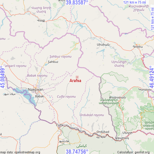
Arafsa GPS coordinates[2]
39° 17' 37.788" North, 45° 47' 17.196" East
| Map corner | latitude | longitude |
|---|---|---|
| Upper-left | 39.83587°, | 45.08499° |
| Center: | 39.29383°, | 45.78811° |
| Lower-right: | 38.74756°, | 46.49124° |
| Map W x H: | 121×121 km | = 75.2×75.2mi |
| max Lat: | 41.75259° ⇑89.2% North |
| Arafsa: | 39.29383° |
| min Lat: | ⇓10.8% South 38.45598° |
| min Long | Arafsa | max Long |
| 44.84846° | 45.78811° | 50.84003° |
| W 13.5%⇐ | ⇒86.5% E |
Elevation
Elevation of Arafsa is 1607 m = 5272 ft, and this is 1224 m = 4016 ft above average elevation for this country.
| Max E: |
2211 m = 7254 ft | 1.1% |
| Arafsa | 1607 m 5272 ft | |
| Avg. | 383 m = 1257 ft | |
Min E: |
-26 m = -85 ft | 98.9% |
See also: Azerbaijan elevation on elevation.city.
Geographical zone
Arafsa is located in North temperate zone (between Tropic of Cancer and the Arctic Circle). Distance of this Northern Tropic circle is 1763.1 km =1095.5 mi to South.| Distance of | km | miles | from Arafsa |
|---|---|---|---|
| North Pole | 5638 | 3503.3 | to North |
| Arctic Circle | 3032.1 | 1884.1 | to North |
| Tropic Cancer | 1763.1 | 1095.5 | to South |
| Equator | 4369.1 | 2714.8 | to South |


Nearby cities:
15 places around Arafsa: (largest is in red/bold)
• Ashagy Aylis
43.9 km =27.3 mi,  156°
156°
• Cahri
32.6 km =20.3 mi,  280°
280°
• Culfa
40.2 km =25 mi,  199°
199°
• Deste
46.8 km =29.1 mi,  167°
167°
• Laçın
73.7 km =45.8 mi,  62°
62°
• Nakhchivan
33.7 km =20.9 mi,  253°
253°
• Ordubad
47.3 km =29.4 mi,  154°
154°
• Oğlanqala
71.6 km =44.5 mi,  297°
297°
• Qubadlı
68.5 km =42.6 mi,  85°
85°
• Qıvraq
59 km =36.7 mi, 281°
• Sumbatan-diza
38.6 km =24 mi,  175°
175°
• Tazakend
33.5 km =20.8 mi,  242°
242°
• Yaycı
39.6 km =24.6 mi,  186°
186°
• Çalxanqala
46.4 km =28.8 mi,  290°
290°
• Şahbuz
22.3 km =13.9 mi, 304°
Sources, notices
• [Note1] Compared only with cities in Azerbaijan existing in our database
• [Src1] Map data: © OpenStreetMap contributors (CC-BY-SA)
• [Src2] Other city data from geonames.org with taken over terms of usage.
• [Src3] Geographical zone / Annual Mean Temperature by Robert A. Rohde @ Wikipedia
