Qubadlı geodata
Qubadlı is a seat of a first-order administrative division; located in Azerbaijan in Asia/Baku (GMT+4) time zone. With population of 6,890 people, there are 96 cities with bigger population in this country. Compared to other cities in Azerbaijan, 88.1% of cities are located further ↑North; 71.9% of cities are located further →East and 66.5% of cities have lower elevation than Qubadlı. Note1


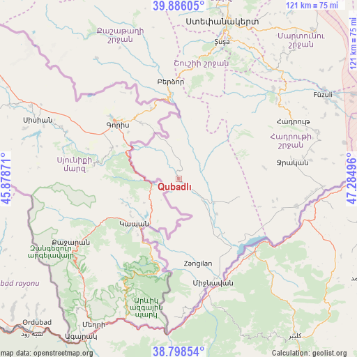
Qubadlı GPS coordinates[2]
39° 20' 39.876" North, 46° 34' 54.588" East
| Map corner | latitude | longitude |
|---|---|---|
| Upper-left | 39.88605°, | 45.87871° |
| Center: | 39.34441°, | 46.58183° |
| Lower-right: | 38.79854°, | 47.28496° |
| Map W x H: | 120.9×120.9 km | = 75.1×75.1mi |
| max Lat: | 41.75259° ⇑88.1% North |
| Qubadlı: | 39.34441° |
| min Lat: | ⇓11.9% South 38.45598° |
| min Long | Qubadlı | max Long |
| 44.84846° | 46.58183° | 50.84003° |
| W 28.1%⇐ | ⇒71.9% E |
Elevation
Elevation of Qubadlı is 482 m = 1581 ft, and this is 99 m = 325 ft above average elevation for this country.
| Max E: |
2211 m = 7254 ft | 33.5% |
| Qubadlı | 482 m 1581 ft | |
| Avg. | 383 m = 1257 ft | |
Min E: |
-26 m = -85 ft | 66.5% |
See also: Azerbaijan elevation on elevation.city.
Geographical zone
Qubadlı is located in North temperate zone (between Tropic of Cancer and the Arctic Circle). Distance of this Northern Tropic circle is 1768.8 km =1099.1 mi to South.| Distance of | km | miles | from Qubadlı |
|---|---|---|---|
| North Pole | 5632.4 | 3499.8 | to North |
| Arctic Circle | 3026.5 | 1880.6 | to North |
| Tropic Cancer | 1768.8 | 1099.1 | to South |
| Equator | 4374.7 | 2718.3 | to South |


Nearby cities:
15 places around Qubadlı: (largest is in red/bold)
• Arafsa
68.5 km =42.6 mi,  265°
265°
• Ashagy Aylis
68.7 km =42.7 mi,  227°
227°
• Fizuli
56.1 km =34.9 mi,  59°
59°
• Hadrut
43.3 km =26.9 mi, 63°
• Horadiz
65.8 km =40.9 mi,  79°
79°
• Jebrail
38.9 km =24.2 mi, 80°
• Laçın
28.4 km =17.6 mi,  354°
354°
• Mincivan
37 km =23 mi,  160°
160°
• Novyy Karanlug
67.6 km =42 mi,  42°
42°
• Ordubad
68.3 km =42.4 mi,  224°
224°
• Qırmızı Bazar
48.7 km =30.3 mi, 40°
• Shushi
48.4 km =30.1 mi,  17°
17°
• Xankandi
54.6 km =33.9 mi, 15°
• Xocalı
65.7 km =40.8 mi, 15°
• Zangilan
29.8 km =18.5 mi,  166°
166°
Sources, notices
• [Note1] Compared only with cities in Azerbaijan existing in our database
• [Src1] Map data: © OpenStreetMap contributors (CC-BY-SA)
• [Src2] Other city data from geonames.org with taken over terms of usage.
• [Src3] Geographical zone / Annual Mean Temperature by Robert A. Rohde @ Wikipedia
