Ordubad geodata
Ordubad (Nakhichevan) is a seat of a second-order administrative division; located in Azerbaijan in Asia/Baku (GMT+4) time zone. With population of 9,781 people, there are 74 cities with bigger population in this country. Compared to other cities in Azerbaijan, 96.2% of cities are located further ↑North; 81.6% of cities are located further →East and 87% of cities have lower elevation than Ordubad. Note1


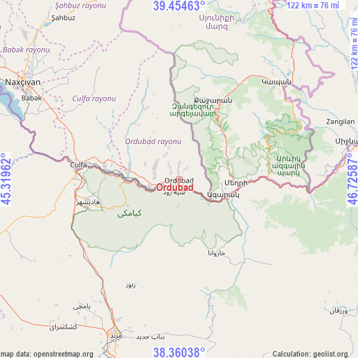
Ordubad GPS coordinates[2]
38° 54' 34.596" North, 46° 1' 21.864" East
| Map corner | latitude | longitude |
|---|---|---|
| Upper-left | 39.45463°, | 45.31962° |
| Center: | 38.90961°, | 46.02274° |
| Lower-right: | 38.36038°, | 46.72587° |
| Map W x H: | 121.7×121.7 km | = 75.6×75.6mi |
| max Lat: | 41.75259° ⇑96.2% North |
| Ordubad: | 38.90961° |
| min Lat: | ⇓3.8% South 38.45598° |
| min Long | Ordubad | max Long |
| 44.84846° | 46.02274° | 50.84003° |
| W 18.4%⇐ | ⇒81.6% E |
Elevation
Elevation of Ordubad is 892 m = 2927 ft, and this is 509 m = 1670 ft above average elevation for this country.
| Max E: |
2211 m = 7254 ft | 13% |
| Ordubad | 892 m 2927 ft | |
| Avg. | 383 m = 1257 ft | |
Min E: |
-26 m = -85 ft | 87% |
See also: Azerbaijan elevation on elevation.city.
Geographical zone
Ordubad is located in North temperate zone (between Tropic of Cancer and the Arctic Circle). Distance of this Northern Tropic circle is 1720.4 km =1069 mi to South.| Distance of | km | miles | from Ordubad |
|---|---|---|---|
| North Pole | 5680.7 | 3529.8 | to North |
| Arctic Circle | 3074.8 | 1910.6 | to North |
| Tropic Cancer | 1720.4 | 1069 | to South |
| Equator | 4326.3 | 2688.2 | to South |


Nearby cities:
15 places around Ordubad: (largest is in red/bold)
• Arafsa
47.3 km =29.4 mi,  334°
334°
• Ashagy Aylis
3.7 km =2.3 mi,  309°
309°
• Cahri
71.6 km =44.5 mi, 312°
• Culfa
34.4 km =21.4 mi,  278°
278°
• Deste
10.2 km =6.3 mi,  253°
253°
• Laçın
89.1 km =55.4 mi,  30°
30°
• Mincivan
62 km =38.5 mi,  77°
77°
• Nakhchivan
62.3 km =38.7 mi,  302°
302°
• Qubadlı
68.3 km =42.4 mi,  44°
44°
• Sumbatan-diza
17.6 km =10.9 mi, 284°
• Tazakend
57 km =35.4 mi, 298°
• Yaycı
25.3 km =15.7 mi, 277°
• Zangilan
58.4 km =36.3 mi,  70°
70°
• Çalxanqala
87 km =54.1 mi, 312°
• Şahbuz
67.5 km =41.9 mi, 325°
Sources, notices
• [Note1] Compared only with cities in Azerbaijan existing in our database
• [Src1] Map data: © OpenStreetMap contributors (CC-BY-SA)
• [Src2] Other city data from geonames.org with taken over terms of usage.
• [Src3] Geographical zone / Annual Mean Temperature by Robert A. Rohde @ Wikipedia
