Nakhchivan geodata
Nakhchivan (Nakhichevan) is a seat of a first-order administrative division; located in Azerbaijan in Asia/Baku (GMT+4) time zone. With population of 64,754 people, there are 10 cities with bigger population in this country. Compared to other cities in Azerbaijan, 90.3% of cities are located further ↑North; 95.7% of cities are located further →East and 85.9% of cities have lower elevation than Nakhchivan. Note1


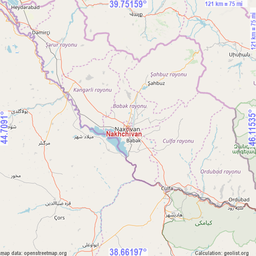
Nakhchivan GPS coordinates[2]
39° 12' 32.004" North, 45° 24' 43.992" East
| Map corner | latitude | longitude |
|---|---|---|
| Upper-left | 39.75159°, | 44.7091° |
| Center: | 39.20889°, | 45.41222° |
| Lower-right: | 38.66197°, | 46.11535° |
| Map W x H: | 121.2×121.2 km | = 75.3×75.3mi |
| max Lat: | 41.75259° ⇑90.3% North |
| Nakhchivan: | 39.20889° |
| min Lat: | ⇓9.7% South 38.45598° |
| min Long | Nakhchivan | max Long |
| 44.84846° | 45.41222° | 50.84003° |
| W 4.3%⇐ | ⇒95.7% E |
Elevation
Elevation of Nakhchivan is 887 m = 2910 ft, and this is 504 m = 1654 ft above average elevation for this country.
| Max E: |
2211 m = 7254 ft | 14.1% |
| Nakhchivan | 887 m 2910 ft | |
| Avg. | 383 m = 1257 ft | |
Min E: |
-26 m = -85 ft | 85.9% |
See also: Nakhchivan elevation on elevation.city.
Geographical zone
Nakhchivan is located in North temperate zone (between Tropic of Cancer and the Arctic Circle). Distance of this Northern Tropic circle is 1753.7 km =1089.7 mi to South.| Distance of | km | miles | from Nakhchivan |
|---|---|---|---|
| North Pole | 5647.4 | 3509.1 | to North |
| Arctic Circle | 3041.6 | 1890 | to North |
| Tropic Cancer | 1753.7 | 1089.7 | to South |
| Equator | 4359.6 | 2708.9 | to South |


Nearby cities:
15 places around Nakhchivan: (largest is in red/bold)
• Arafsa
33.7 km =20.9 mi,  73°
73°
• Ashagy Aylis
58.7 km =36.5 mi,  121°
121°
• Cahri
15.5 km =9.6 mi,  1°
1°
• Culfa
34 km =21.1 mi,  146°
146°
• Deste
56.1 km =34.9 mi,  130°
130°
• Ordubad
62.3 km =38.7 mi, 122°
• Oğlanqala
52.5 km =32.6 mi,  323°
323°
• Qıvraq
33.2 km =20.6 mi,  309°
309°
• Sedarak
72.2 km =44.9 mi, 321°
• Sharur City
53.3 km =33.1 mi, 315°
• Sumbatan-diza
46 km =28.6 mi, 129°
• Tazakend
6.6 km =4.1 mi,  156°
156°
• Yaycı
40.7 km =25.3 mi,  137°
137°
• Çalxanqala
28.2 km =17.5 mi,  336°
336°
• Şahbuz
26.1 km =16.2 mi,  32°
32°
Sources, notices
• [Note1] Compared only with cities in Azerbaijan existing in our database
• [Src1] Map data: © OpenStreetMap contributors (CC-BY-SA)
• [Src2] Other city data from geonames.org with taken over terms of usage.
• [Src3] Geographical zone / Annual Mean Temperature by Robert A. Rohde @ Wikipedia
