Oğlanqala geodata
Oğlanqala (Nakhichevan) is a populated place; located in Azerbaijan in Asia/Baku (GMT+4) time zone. With population of 2,897 people, there are 128 cities with bigger population in this country. Compared to other cities in Azerbaijan, 81.1% of cities are located further ↑North; 98.4% of cities are located further →East and 84.3% of cities have lower elevation than Oğlanqala. Note1


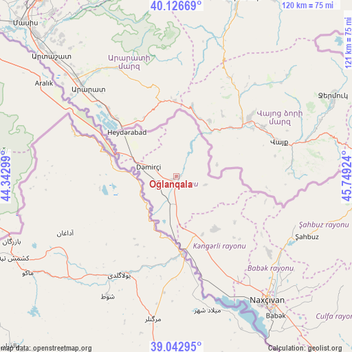
Oğlanqala GPS coordinates[2]
39° 35' 12.984" North, 45° 2' 45.996" East
| Map corner | latitude | longitude |
|---|---|---|
| Upper-left | 40.12669°, | 44.34299° |
| Center: | 39.58694°, | 45.04611° |
| Lower-right: | 39.04295°, | 45.74924° |
| Map W x H: | 120.5×120.5 km | = 74.9×74.9mi |
| max Lat: | 41.75259° ⇑81.1% North |
| Oğlanqala: | 39.58694° |
| min Lat: | ⇓18.9% South 38.45598° |
| min Long | Oğlanqala | max Long |
| 44.84846° | 45.04611° | 50.84003° |
| W 1.6%⇐ | ⇒98.4% E |
Elevation
Elevation of Oğlanqala is 853 m = 2799 ft, and this is 470 m = 1542 ft above average elevation for this country.
| Max E: |
2211 m = 7254 ft | 15.7% |
| Oğlanqala | 853 m 2799 ft | |
| Avg. | 383 m = 1257 ft | |
Min E: |
-26 m = -85 ft | 84.3% |
See also: Azerbaijan elevation on elevation.city.
Geographical zone
Oğlanqala is located in North temperate zone (between Tropic of Cancer and the Arctic Circle). Distance of this Northern Tropic circle is 1795.7 km =1115.8 mi to South.| Distance of | km | miles | from Oğlanqala |
|---|---|---|---|
| North Pole | 5605.4 | 3483 | to North |
| Arctic Circle | 2999.5 | 1863.8 | to North |
| Tropic Cancer | 1795.7 | 1115.8 | to South |
| Equator | 4401.7 | 2735.1 | to South |


Nearby cities:
15 places around Oğlanqala: (largest is in red/bold)
• Arafsa
71.6 km =44.5 mi,  117°
117°
• Cahri
41.3 km =25.7 mi,  129°
129°
• Culfa
86.5 km =53.7 mi,  144°
144°
• Heydarabad
22.7 km =14.1 mi,  311°
311°
• Kerbakhiar
103.2 km =64.1 mi,  55°
55°
• Nakhchivan
52.5 km =32.6 mi, 143°
• Qıvraq
21.7 km =13.5 mi,  164°
164°
• Sedarak
19.8 km =12.3 mi,  315°
315°
• Sharur City
6.8 km =4.2 mi,  236°
236°
• Sumbatan-diza
97.7 km =60.7 mi, 136°
• Tazakend
58.9 km =36.6 mi, 144°
• Yaycı
93 km =57.8 mi, 140°
• Çalxanqala
26 km =16.2 mi, 128°
• İstisu
87.8 km =54.6 mi, 62°
• Şahbuz
49.5 km =30.8 mi,  113°
113°
Sources, notices
• [Note1] Compared only with cities in Azerbaijan existing in our database
• [Src1] Map data: © OpenStreetMap contributors (CC-BY-SA)
• [Src2] Other city data from geonames.org with taken over terms of usage.
• [Src3] Geographical zone / Annual Mean Temperature by Robert A. Rohde @ Wikipedia
