Qıvraq geodata
Qıvraq (Nakhichevan) is a seat of a second-order administrative division; located in Azerbaijan in Asia/Baku (GMT+4) time zone. In our database, there are 183 cities with bigger population. Compared to other cities in Azerbaijan, 85.9% of cities are located further ↑North; 97.8% of cities are located further →East and 87.6% of cities have lower elevation than Qıvraq. Note1


Qıvraq GPS coordinates[2]
39° 23' 57.804" North, 45° 6' 54.468" East
| Map corner | latitude | longitude |
|---|---|---|
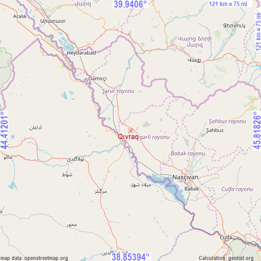
| Upper-left | 39.9406°, | 44.41201° |
| Center: | 39.39939°, | 45.11513° |
| Lower-right: | 38.85394°, | 45.81826° |
| Map W x H: | 120.8×120.8 km | = 75.1×75.1mi |
| max Lat: | 41.75259° ⇑85.9% North |
| Qıvraq: | 39.39939° |
| min Lat: | ⇓14.1% South 38.45598° |
| min Long | Qıvraq | max Long |
| 44.84846° | 45.11513° | 50.84003° |
| W 2.2%⇐ | ⇒97.8% E |
Elevation
Elevation of Qıvraq is 915 m = 3002 ft, and this is 532 m = 1745 ft above average elevation for this country.
| Max E: |
2211 m = 7254 ft | 12.4% |
| Qıvraq | 915 m 3002 ft | |
| Avg. | 383 m = 1257 ft | |
Min E: |
-26 m = -85 ft | 87.6% |
See also: Azerbaijan elevation on elevation.city.
Geographical zone
Qıvraq is located in North temperate zone (between Tropic of Cancer and the Arctic Circle). Distance of this Northern Tropic circle is 1774.9 km =1102.9 mi to South.| Distance of | km | miles | from Qıvraq |
|---|---|---|---|
| North Pole | 5626.3 | 3496 | to North |
| Arctic Circle | 3020.4 | 1876.8 | to North |
| Tropic Cancer | 1774.9 | 1102.9 | to South |
| Equator | 4380.8 | 2722.1 | to South |


Nearby cities:
15 places around Qıvraq: (largest is in red/bold)
• Arafsa
59 km =36.7 mi,  101°
101°
• Ashagy Aylis
91.6 km =56.9 mi,  124°
124°
• Cahri
26.4 km =16.4 mi, 102°
• Culfa
66.5 km =41.3 mi,  138°
138°
• Deste
89.3 km =55.5 mi,  129°
129°
• Heydarabad
42.6 km =26.5 mi,  327°
327°
• Nakhchivan
33.2 km =20.6 mi, 129°
• Oğlanqala
21.7 km =13.5 mi,  344°
344°
• Sedarak
40.2 km =25 mi, 330°
• Sharur City
20.6 km =12.8 mi, 325°
• Sumbatan-diza
79.2 km =49.2 mi, 129°
• Tazakend
39.2 km =24.4 mi, 133°
• Yaycı
73.7 km =45.8 mi, 133°
• Çalxanqala
15.2 km =9.4 mi,  71°
71°
• Şahbuz
39.4 km =24.5 mi,  88°
88°
Sources, notices
• [Note1] Compared only with cities in Azerbaijan existing in our database
• [Src1] Map data: © OpenStreetMap contributors (CC-BY-SA)
• [Src2] Other city data from geonames.org with taken over terms of usage.
• [Src3] Geographical zone / Annual Mean Temperature by Robert A. Rohde @ Wikipedia
