Heydarabad geodata
Heydarabad (Nakhichevan) is a seat of a second-order administrative division; located in Azerbaijan in Asia/Baku (GMT+4) time zone. In our database, there are 183 cities with bigger population. Compared to other cities in Azerbaijan, 77.3% of cities are located further ↑North; 100% of cities are located further →East and 82.7% of cities have lower elevation than Heydarabad. Note1


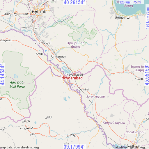
Heydarabad GPS coordinates[2]
39° 43' 22.296" North, 44° 50' 54.456" East
| Map corner | latitude | longitude |
|---|---|---|
| Upper-left | 40.26154°, | 44.14534° |
| Center: | 39.72286°, | 44.84846° |
| Lower-right: | 39.17994°, | 45.55159° |
| Map W x H: | 120.3×120.3 km | = 74.8×74.8mi |
| max Lat: | 41.75259° ⇑77.3% North |
| Heydarabad: | 39.72286° |
| min Lat: | ⇓22.7% South 38.45598° |
| min Long | Heydarabad | max Long |
| 44.84846° | 44.84846° | 50.84003° |
| W 0%⇐ | ⇒100% E |
Elevation
Elevation of Heydarabad is 818 m = 2684 ft, and this is 435 m = 1427 ft above average elevation for this country.
| Max E: |
2211 m = 7254 ft | 17.3% |
| Heydarabad | 818 m 2684 ft | |
| Avg. | 383 m = 1257 ft | |
Min E: |
-26 m = -85 ft | 82.7% |
See also: Azerbaijan elevation on elevation.city.
Geographical zone
Heydarabad is located in North temperate zone (between Tropic of Cancer and the Arctic Circle). Distance of this Northern Tropic circle is 1810.8 km =1125.2 mi to South.| Distance of | km | miles | from Heydarabad |
|---|---|---|---|
| North Pole | 5590.3 | 3473.7 | to North |
| Arctic Circle | 2984.4 | 1854.4 | to North |
| Tropic Cancer | 1810.8 | 1125.2 | to South |
| Equator | 4416.8 | 2744.5 | to South |


Nearby cities:
15 places around Heydarabad: (largest is in red/bold)
• Arafsa
93.7 km =58.2 mi,  120°
120°
• Arıqıran
111.7 km =69.4 mi,  35°
35°
• Cahri
64 km =39.8 mi,  130°
130°
• Culfa
108.7 km =67.5 mi,  141°
141°
• Kerbakhiar
110.7 km =68.8 mi,  67°
67°
• Nakhchivan
74.9 km =46.5 mi, 139°
• Oğlanqala
22.7 km =14.1 mi, 131°
• Qıvraq
42.6 km =26.5 mi,  147°
147°
• Sedarak
3.2 km =2 mi,  107°
107°
• Sharur City
22 km =13.7 mi, 149°
• Tazakend
81.2 km =50.5 mi, 141°
• Yaycı
115.5 km =71.8 mi, 138°
• Çalxanqala
48.6 km =30.2 mi, 129°
• İstisu
98.2 km =61 mi,  75°
75°
• Şahbuz
71.4 km =44.4 mi, 119°
Sources, notices
• [Note1] Compared only with cities in Azerbaijan existing in our database
• [Src1] Map data: © OpenStreetMap contributors (CC-BY-SA)
• [Src2] Other city data from geonames.org with taken over terms of usage.
• [Src3] Geographical zone / Annual Mean Temperature by Robert A. Rohde @ Wikipedia
