Zaqatala geodata
Zaqatala is a seat of a first-order administrative division; located in Azerbaijan in Asia/Baku (GMT+4) time zone. With population of 18,277 people, there are 44 cities with bigger population in this country. Compared to other cities in Azerbaijan, 98.4% of cities are located further ↓South; 70.8% of cities are located further →East and 68.1% of cities have lower elevation than Zaqatala. Note1


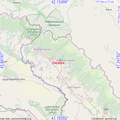
Zaqatala GPS coordinates[2]
41° 37' 53.76" North, 46° 38' 41.244" East
| Map corner | latitude | longitude |
|---|---|---|
| Upper-left | 42.15499°, | 45.94167° |
| Center: | 41.6316°, | 46.64479° |
| Lower-right: | 41.10392°, | 47.34792° |
| Map W x H: | 116.9×116.9 km | = 72.6×72.6mi |
| max Lat: | 41.75259° ⇑1.6% North |
| Zaqatala: | 41.6316° |
| min Lat: | ⇓98.4% South 38.45598° |
| min Long | Zaqatala | max Long |
| 44.84846° | 46.64479° | 50.84003° |
| W 29.2%⇐ | ⇒70.8% E |
Elevation
Elevation of Zaqatala is 503 m = 1650 ft, and this is 120 m = 394 ft above average elevation for this country.
| Max E: |
2211 m = 7254 ft | 31.9% |
| Zaqatala | 503 m 1650 ft | |
| Avg. | 383 m = 1257 ft | |
Min E: |
-26 m = -85 ft | 68.1% |
See also: Azerbaijan elevation on elevation.city.
Geographical zone
Zaqatala is located in North temperate zone (between Tropic of Cancer and the Arctic Circle). Distance of this Northern Tropic circle is 2023.1 km =1257.1 mi to South.| Distance of | km | miles | from Zaqatala |
|---|---|---|---|
| North Pole | 5378.1 | 3341.8 | to North |
| Arctic Circle | 2772.2 | 1722.6 | to North |
| Tropic Cancer | 2023.1 | 1257.1 | to South |
| Equator | 4629 | 2876.3 | to South |


Nearby cities:
15 places around Zaqatala: (largest is in red/bold)
• Aliabad
16.6 km =10.3 mi,  182°
182°
• Baş Göynük
51.8 km =32.2 mi,  131°
131°
• Belokany
22.5 km =14 mi,  297°
297°
• Faldarlı
21.1 km =13.1 mi,  210°
210°
• Mamrux
14.2 km =8.8 mi, 134°
• Oğuz
92.6 km =57.5 mi, 132°
• Qabaqçöl
33.9 km =21.1 mi,  293°
293°
• Qandax
19.4 km =12.1 mi, 206°
• Qasım İsmayılov
96.6 km =60 mi,  199°
199°
• Qax
33 km =20.5 mi,  135°
135°
• Qax İngiloy
33.6 km =20.9 mi, 133°
• Qaxbaş
34.6 km =21.5 mi, 129°
• Qırmızı Samux
80.1 km =49.8 mi, 196°
• Sheki
65.7 km =40.8 mi, 138°
• Çinarlı
28.9 km =18 mi, 128°
Sources, notices
• [Note1] Compared only with cities in Azerbaijan existing in our database
• [Src1] Map data: © OpenStreetMap contributors (CC-BY-SA)
• [Src2] Other city data from geonames.org with taken over terms of usage.
• [Src3] Geographical zone / Annual Mean Temperature by Robert A. Rohde @ Wikipedia
