Lahıc geodata
Lahıc (İsmayıllı) is a populated place; located in Azerbaijan in Asia/Baku (GMT+4) time zone. With population of 925 people, there are 176 cities with bigger population in this country. Compared to other cities in Azerbaijan, 80% of cities are located further ↓South; 57.3% of cities are located further ←West and 92.4% of cities have lower elevation than Lahıc. Note1


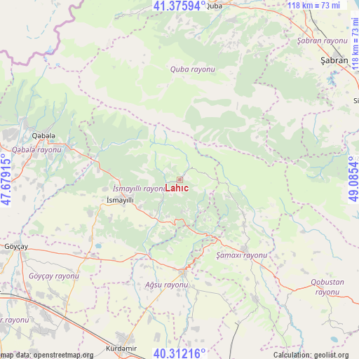
Lahıc GPS coordinates[2]
40° 50' 46.248" North, 48° 22' 56.172" East
| Map corner | latitude | longitude |
|---|---|---|
| Upper-left | 41.37594°, | 47.67915° |
| Center: | 40.84618°, | 48.38227° |
| Lower-right: | 40.31216°, | 49.0854° |
| Map W x H: | 118.3×118.3 km | = 73.5×73.5mi |
| max Lat: | 41.75259° ⇑20% North |
| Lahıc: | 40.84618° |
| min Lat: | ⇓80% South 38.45598° |
| min Long | Lahıc | max Long |
| 44.84846° | 48.38227° | 50.84003° |
| W 57.3%⇐ | ⇒42.7% E |
Elevation
Elevation of Lahıc is 1215 m = 3986 ft, and this is 832 m = 2730 ft above average elevation for this country.
| Max E: |
2211 m = 7254 ft | 7.6% |
| Lahıc | 1215 m 3986 ft | |
| Avg. | 383 m = 1257 ft | |
Min E: |
-26 m = -85 ft | 92.4% |
See also: Azerbaijan elevation on elevation.city.
Geographical zone
Lahıc is located in North temperate zone (between Tropic of Cancer and the Arctic Circle). Distance of this Northern Tropic circle is 1935.8 km =1202.8 mi to South.| Distance of | km | miles | from Lahıc |
|---|---|---|---|
| North Pole | 5465.4 | 3396 | to North |
| Arctic Circle | 2859.5 | 1776.8 | to North |
| Tropic Cancer | 1935.8 | 1202.8 | to South |
| Equator | 4541.7 | 2822.1 | to South |


Nearby cities:
15 places around Lahıc: (largest is in red/bold)
• Aghsu
30.7 km =19.1 mi,  177°
177°
• Altıağac
46.5 km =28.9 mi,  88°
88°
• Basqal
10.1 km =6.3 mi, 175°
• Divichibazar
64.3 km =40 mi,  52°
52°
• Geoktschai
58.1 km =36.1 mi,  248°
248°
• Gilgilçay
67.8 km =42.1 mi,  61°
61°
• Khyzy
58.6 km =36.4 mi,  83°
83°
• Kyurdarmir
59.2 km =36.8 mi,  198°
198°
• Kyzyl-Burun
66.8 km =41.5 mi,  67°
67°
• Qobustan
57.7 km =35.9 mi,  127°
127°
• Quba
58.3 km =36.2 mi,  10°
10°
• Qusar
64.8 km =40.3 mi,  3°
3°
• Qutqashen
47.3 km =29.4 mi,  288°
288°
• Shamakhi
32.4 km =20.1 mi,  137°
137°
• İsmayıllı
20.6 km =12.8 mi, 250°
Sources, notices
• [Note1] Compared only with cities in Azerbaijan existing in our database
• [Src1] Map data: © OpenStreetMap contributors (CC-BY-SA)
• [Src2] Other city data from geonames.org with taken over terms of usage.
• [Src3] Geographical zone / Annual Mean Temperature by Robert A. Rohde @ Wikipedia
