Saidpur geodata
Saidpur (Rajshahi Division) is a populated place; located in Bangladesh in Asia/Dhaka (GMT+6) time zone. With population of 199,422 people, there are 20 cities with bigger population in this country. Compared to other cities in Bangladesh, 95.7% of cities are located further ↓South; 92.3% of cities are located further →East and 96.6% of cities have lower elevation than Saidpur. Note1


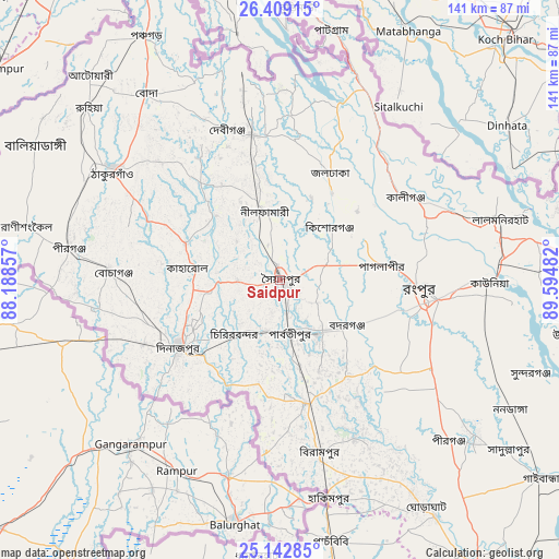
Saidpur GPS coordinates[2]
25° 46' 39.684" North, 88° 53' 30.084" East
| Map corner | latitude | longitude |
|---|---|---|
| Upper-left | 26.40915°, | 88.18857° |
| Center: | 25.77769°, | 88.89169° |
| Lower-right: | 25.14285°, | 89.59482° |
| Map W x H: | 140.8×140.8 km | = 87.5×87.5mi |
| max Lat: | 26.33338° ⇑4.3% North |
| Saidpur: | 25.77769° |
| min Lat: | ⇓95.7% South 20.85829° |
| min Long | Saidpur | max Long |
| 88.15638° | 88.89169° | 92.29773° |
| W 7.7%⇐ | ⇒92.3% E |
Elevation
Elevation of Saidpur is 43 m = 141 ft, and this is 25.1 m = 82 ft above average elevation for this country.
| Max E: |
79 m = 259 ft | 3.4% |
| Saidpur | 43 m 141 ft | |
| Avg. | 17.9 m = 59 ft | |
Min E: |
2 m = 7 ft | 96.6% |
See also: Saidpur elevation on elevation.city.
Geographical zone
Saidpur is located in North temperate zone (between Tropic of Cancer and the Arctic Circle). Distance of this Northern Tropic circle is 260.3 km =161.7 mi to South.| Distance of | km | miles | from Saidpur |
|---|---|---|---|
| North Pole | 7140.9 | 4437.1 | to North |
| Arctic Circle | 4535 | 2817.9 | to North |
| Tropic Cancer | 260.3 | 161.7 | to South |
| Equator | 2866.2 | 1781 | to South |


Nearby cities:
15 places around Saidpur: (largest is in red/bold)
• Badarganj
19.9 km =12.4 mi,  125°
125°
• Chilmāri
81.9 km =50.9 mi,  107°
107°
• Dinājpur
30.4 km =18.9 mi,  236°
236°
• Gaibandha
82.2 km =51.1 mi, 127°
• Joypur Hāt
76.4 km =47.5 mi,  169°
169°
• Lalmonirhat
57.6 km =35.8 mi,  74°
74°
• Mahasthangarh
101.5 km =63.1 mi,  153°
153°
• Nageswari
82.8 km =51.4 mi,  75°
75°
• Paharpur
83.9 km =52.1 mi, 174°
• Panchagarh
70.2 km =43.6 mi,  331°
331°
• Parbatipur
13.3 km =8.3 mi,  162°
162°
• Pīrgaaj
54 km =33.6 mi,  279°
279°
• Rangpur
36.2 km =22.5 mi,  95°
95°
• Shibganj
96.6 km =60 mi, 153°
• Thākurgaon
50.7 km =31.5 mi,  303°
303°
Sources, notices
• [Note1] Compared only with cities in Bangladesh existing in our database
• [Src1] Map data: © OpenStreetMap contributors (CC-BY-SA)
• [Src2] Other city data from geonames.org with taken over terms of usage.
• [Src3] Geographical zone / Annual Mean Temperature by Robert A. Rohde @ Wikipedia
