Lalmonirhat geodata
Lalmonirhat (Rangpur Division) is a seat of a second-order administrative division; located in Bangladesh in Asia/Dhaka (GMT+6) time zone. With population of 65,127 people, there are 50 cities with bigger population in this country. Compared to other cities in Bangladesh, 97.4% of cities are located further ↓South; 72.6% of cities are located further →East and 93.2% of cities have lower elevation than Lalmonirhat. Note1
Administrative division(s):
- Level 1: Rangpur Division
- Level 2: Lalmonirhat District
- Level 3: Lalmonirhat Sadar Upazila
- Level 4: Paurashava


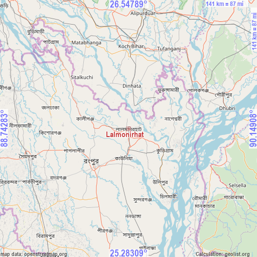
Lalmonirhat GPS coordinates[2]
25° 55' 1.884" North, 89° 26' 45.42" East
| Map corner | latitude | longitude |
|---|---|---|
| Upper-left | 26.54789°, | 88.74283° |
| Center: | 25.91719°, | 89.44595° |
| Lower-right: | 25.28309°, | 90.14908° |
| Map W x H: | 140.6×140.6 km | = 87.4×87.4mi |
| max Lat: | 26.33338° ⇑2.6% North |
| Lalmonirhat: | 25.91719° |
| min Lat: | ⇓97.4% South 20.85829° |
| min Long | Lalmonirhat | max Long |
| 88.15638° | 89.44595° | 92.29773° |
| W 27.4%⇐ | ⇒72.6% E |
Elevation
Elevation of Lalmonirhat is 38 m = 125 ft, and this is 20.1 m = 66 ft above average elevation for this country.
| Max E: |
79 m = 259 ft | 6.8% |
| Lalmonirhat | 38 m 125 ft | |
| Avg. | 17.9 m = 59 ft | |
Min E: |
2 m = 7 ft | 93.2% |
See also: Lalmonirhat elevation on elevation.city.
Geographical zone
Lalmonirhat is located in North temperate zone (between Tropic of Cancer and the Arctic Circle). Distance of this Northern Tropic circle is 275.8 km =171.4 mi to South.| Distance of | km | miles | from Lalmonirhat |
|---|---|---|---|
| North Pole | 7125.3 | 4427.5 | to North |
| Arctic Circle | 4519.5 | 2808.3 | to North |
| Tropic Cancer | 275.8 | 171.4 | to South |
| Equator | 2881.7 | 1790.6 | to South |


Nearby cities:
15 places around Lalmonirhat: (largest is in red/bold)
• Badarganj
47.7 km =29.6 mi,  235°
235°
• Chilmāri
46 km =28.6 mi,  150°
150°
• Dinājpur
87.1 km =54.1 mi,  248°
248°
• Gaibandha
66.1 km =41.1 mi,  171°
171°
• Joypur Hāt
100 km =62.1 mi,  204°
204°
• Mahasthangarh
106.8 km =66.4 mi,  185°
185°
• Nageswari
25.2 km =15.7 mi,  77°
77°
• Paharpur
109.7 km =68.2 mi,  205°
205°
• Panchagarh
100 km =62.1 mi,  297°
297°
• Parbatipur
58.8 km =36.5 mi, 241°
• Pīrgaaj
108.9 km =67.7 mi,  266°
266°
• Rangpur
27.2 km =16.9 mi,  225°
225°
• Saidpur
57.6 km =35.8 mi, 254°
• Shibganj
102.6 km =63.8 mi, 186°
• Thākurgaon
98.4 km =61.1 mi,  277°
277°
Sources, notices
• [Note1] Compared only with cities in Bangladesh existing in our database
• [Src1] Map data: © OpenStreetMap contributors (CC-BY-SA)
• [Src2] Other city data from geonames.org with taken over terms of usage.
• [Src3] Geographical zone / Annual Mean Temperature by Robert A. Rohde @ Wikipedia
