Rangpur geodata
Rangpur (Rangpur Division) is a seat of a first-order administrative division; located in Bangladesh in Asia/Dhaka (GMT+6) time zone. With population of 343,122 people, there are 7 cities with bigger population in this country. Compared to other cities in Bangladesh, 94.9% of cities are located further ↓South; 77.8% of cities are located further →East and 92.3% of cities have lower elevation than Rangpur. Note1
Administrative division(s):
- Level 1: Rangpur Division
- Level 2: Rangpur
- Level 3: Rangpur Sadar
- Level 4: Paurashava


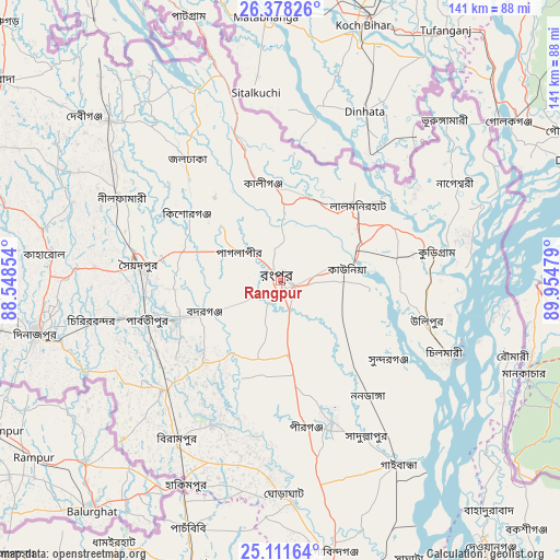
Rangpur GPS coordinates[2]
25° 44' 47.904" North, 89° 15' 5.976" East
| Map corner | latitude | longitude |
|---|---|---|
| Upper-left | 26.37826°, | 88.54854° |
| Center: | 25.74664°, | 89.25166° |
| Lower-right: | 25.11164°, | 89.95479° |
| Map W x H: | 140.8×140.8 km | = 87.5×87.5mi |
| max Lat: | 26.33338° ⇑5.1% North |
| Rangpur: | 25.74664° |
| min Lat: | ⇓94.9% South 20.85829° |
| min Long | Rangpur | max Long |
| 88.15638° | 89.25166° | 92.29773° |
| W 22.2%⇐ | ⇒77.8% E |
Elevation
Elevation of Rangpur is 36 m = 118 ft, and this is 18.1 m = 59 ft above average elevation for this country.
| Max E: |
79 m = 259 ft | 7.7% |
| Rangpur | 36 m 118 ft | |
| Avg. | 17.9 m = 59 ft | |
Min E: |
2 m = 7 ft | 92.3% |
See also: Rangpur elevation on elevation.city.
Geographical zone
Rangpur is located in North temperate zone (between Tropic of Cancer and the Arctic Circle). Distance of this Northern Tropic circle is 256.8 km =159.6 mi to South.| Distance of | km | miles | from Rangpur |
|---|---|---|---|
| North Pole | 7144.3 | 4439.3 | to North |
| Arctic Circle | 4538.4 | 2820 | to North |
| Tropic Cancer | 256.8 | 159.6 | to South |
| Equator | 2862.8 | 1778.9 | to South |


Nearby cities:
15 places around Rangpur: (largest is in red/bold)
• Badarganj
21.4 km =13.3 mi,  247°
247°
• Chilmāri
47.1 km =29.3 mi,  116°
116°
• Dinājpur
62.9 km =39.1 mi,  257°
257°
• Gaibandha
54.9 km =34.1 mi,  147°
147°
• Joypur Hāt
75.2 km =46.7 mi,  197°
197°
• Lalmonirhat
27.2 km =16.9 mi,  45°
45°
• Mahasthangarh
87.8 km =54.6 mi,  174°
174°
• Nageswari
50.4 km =31.3 mi,  60°
60°
• Paharpur
84.7 km =52.6 mi, 199°
• Panchagarh
95.2 km =59.2 mi,  313°
313°
• Parbatipur
33.4 km =20.8 mi, 253°
• Pīrgaaj
90.1 km =56 mi,  277°
277°
• Saidpur
36.2 km =22.5 mi, 275°
• Shibganj
83.2 km =51.7 mi,  175°
175°
• Thākurgaon
84.3 km =52.4 mi,  292°
292°
Sources, notices
• [Note1] Compared only with cities in Bangladesh existing in our database
• [Src1] Map data: © OpenStreetMap contributors (CC-BY-SA)
• [Src2] Other city data from geonames.org with taken over terms of usage.
• [Src3] Geographical zone / Annual Mean Temperature by Robert A. Rohde @ Wikipedia
