Nageswari geodata
Nageswari (Rangpur Division) is a populated place; located in Bangladesh in Asia/Dhaka (GMT+6) time zone. With population of 49,425 people, there are 64 cities with bigger population in this country. Compared to other cities in Bangladesh, 98.3% of cities are located further ↓South; 65% of cities are located further →East and 90.6% of cities have lower elevation than Nageswari. Note1
Administrative division(s):
- Level 1: Rangpur Division
- Level 2: Kurigram
- Level 3: Nageshwari
- Level 4: Nageshwari


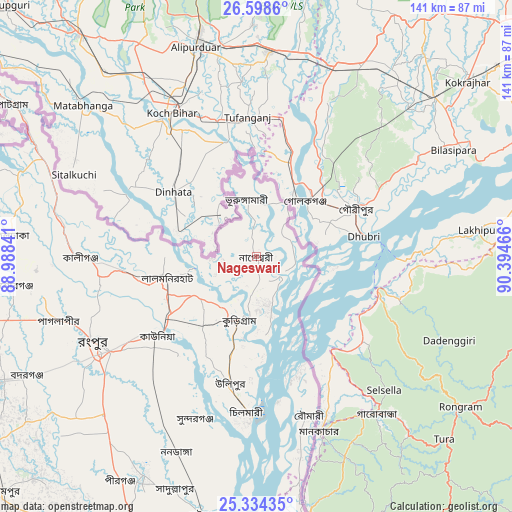
Nageswari GPS coordinates[2]
25° 58' 5.412" North, 89° 41' 29.508" East
| Map corner | latitude | longitude |
|---|---|---|
| Upper-left | 26.5986°, | 88.98841° |
| Center: | 25.96817°, | 89.69153° |
| Lower-right: | 25.33435°, | 90.39466° |
| Map W x H: | 140.6×140.6 km | = 87.4×87.4mi |
| max Lat: | 26.33338° ⇑1.7% North |
| Nageswari: | 25.96817° |
| min Lat: | ⇓98.3% South 20.85829° |
| min Long | Nageswari | max Long |
| 88.15638° | 89.69153° | 92.29773° |
| W 35%⇐ | ⇒65% E |
Elevation
Elevation of Nageswari is 33 m = 108 ft, and this is 15.1 m = 50 ft above average elevation for this country.
| Max E: |
79 m = 259 ft | 9.4% |
| Nageswari | 33 m 108 ft | |
| Avg. | 17.9 m = 59 ft | |
Min E: |
2 m = 7 ft | 90.6% |
See also: Nageswari elevation on elevation.city.
Geographical zone
Nageswari is located in North temperate zone (between Tropic of Cancer and the Arctic Circle). Distance of this Northern Tropic circle is 281.5 km =174.9 mi to South.| Distance of | km | miles | from Nageswari |
|---|---|---|---|
| North Pole | 7119.7 | 4424 | to North |
| Arctic Circle | 4513.8 | 2804.7 | to North |
| Tropic Cancer | 281.5 | 174.9 | to South |
| Equator | 2887.4 | 1794.1 | to South |


Nearby cities:
15 places around Nageswari: (largest is in red/bold)
• Badarganj
71.7 km =44.6 mi,  242°
242°
• Chilmāri
45.9 km =28.5 mi,  182°
182°
• Dinājpur
112.1 km =69.7 mi,  250°
250°
• Gaibandha
72.6 km =45.1 mi,  191°
191°
• Jamālpur
119.4 km =74.2 mi,  167°
167°
• Joypur Hāt
117.2 km =72.8 mi,  214°
214°
• Lalmonirhat
25.2 km =15.7 mi,  257°
257°
• Mahasthangarh
117.3 km =72.9 mi,  197°
197°
• Panchagarh
120.2 km =74.7 mi,  289°
289°
• Parbatipur
83.3 km =51.8 mi, 246°
• Rangpur
50.4 km =31.3 mi, 240°
• Saidpur
82.8 km =51.4 mi, 255°
• Sherpur
110.5 km =68.7 mi,  162°
162°
• Shibganj
113.7 km =70.6 mi, 199°
• Thākurgaon
122.3 km =76 mi,  273°
273°
Sources, notices
• [Note1] Compared only with cities in Bangladesh existing in our database
• [Src1] Map data: © OpenStreetMap contributors (CC-BY-SA)
• [Src2] Other city data from geonames.org with taken over terms of usage.
• [Src3] Geographical zone / Annual Mean Temperature by Robert A. Rohde @ Wikipedia
