Paharpur geodata
Paharpur (Rajshahi Division) is a populated place; located in Bangladesh in Asia/Dhaka (GMT+6) time zone. With population of 1,000 people, there are 114 cities with bigger population in this country. Compared to other cities in Bangladesh, 88% of cities are located further ↓South; 89.7% of cities are located further →East and 79.5% of cities have lower elevation than Paharpur. Note1
Administrative division(s):
- Level 1: Rajshahi Division
- Level 2: Naogaon
- Level 3: Badalgachhi
- Level 4: Jagadishpur


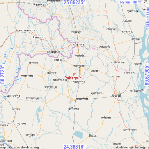
Paharpur GPS coordinates[2]
25° 1' 36.876" North, 88° 58' 33.312" East
| Map corner | latitude | longitude |
|---|---|---|
| Upper-left | 25.66235°, | 88.2728° |
| Center: | 25.02691°, | 88.97592° |
| Lower-right: | 24.38816°, | 89.67905° |
| Map W x H: | 141.7×141.7 km | = 88×88mi |
| max Lat: | 26.33338° ⇑12% North |
| Paharpur: | 25.02691° |
| min Lat: | ⇓88% South 20.85829° |
| min Long | Paharpur | max Long |
| 88.15638° | 88.97592° | 92.29773° |
| W 10.3%⇐ | ⇒89.7% E |
Elevation
Elevation of Paharpur is 24 m = 79 ft, and this is 6.1 m = 20 ft above average elevation for this country.
| Max E: |
79 m = 259 ft | 20.5% |
| Paharpur | 24 m 79 ft | |
| Avg. | 17.9 m = 59 ft | |
Min E: |
2 m = 7 ft | 79.5% |
See also: Bangladesh elevation on elevation.city.
Geographical zone
Paharpur is located in North temperate zone (between Tropic of Cancer and the Arctic Circle). Distance of this Northern Tropic circle is 176.8 km =109.9 mi to South.| Distance of | km | miles | from Paharpur |
|---|---|---|---|
| North Pole | 7224.3 | 4489 | to North |
| Arctic Circle | 4618.4 | 2869.7 | to North |
| Tropic Cancer | 176.8 | 109.9 | to South |
| Equator | 2782.7 | 1729.1 | to South |


Nearby cities:
15 places around Paharpur: (largest is in red/bold)
• Badarganj
72.4 km =45 mi,  6°
6°
• Bogra
44.4 km =27.6 mi,  116°
116°
• Dinājpur
74.9 km =46.5 mi,  333°
333°
• Gaibandha
66.3 km =41.2 mi,  59°
59°
• Joypur Hāt
9.8 km =6.1 mi,  31°
31°
• Mahasthangarh
37.7 km =23.4 mi,  101°
101°
• Natore
68.5 km =42.6 mi,  179°
179°
• Nawābganj
85.8 km =53.3 mi,  235°
235°
• Parbatipur
70.9 km =44.1 mi,  356°
356°
• Puthia
74.9 km =46.5 mi,  191°
191°
• Pār Naogaon
24.9 km =15.5 mi, 186°
• Rangpur
84.7 km =52.6 mi,  19°
19°
• Rājshāhi
81.9 km =50.9 mi,  207°
207°
• Saidpur
83.9 km =52.1 mi,  354°
354°
• Shibganj
35.1 km =21.8 mi,  94°
94°
Sources, notices
• [Note1] Compared only with cities in Bangladesh existing in our database
• [Src1] Map data: © OpenStreetMap contributors (CC-BY-SA)
• [Src2] Other city data from geonames.org with taken over terms of usage.
• [Src3] Geographical zone / Annual Mean Temperature by Robert A. Rohde @ Wikipedia
