Shibganj geodata
Shibganj (Rajshahi Division) is a populated place; located in Bangladesh in Asia/Dhaka (GMT+6) time zone. With population of 35,961 people, there are 89 cities with bigger population in this country. Compared to other cities in Bangladesh, 76.1% of cities are located further ↓South; 100% of cities are located further →East and 89.7% of cities have lower elevation than Shibganj. Note1
Administrative division(s):
- Level 1: Rajshahi Division
- Level 2: Chapai Nababganj
- Level 3: Shibganj
- Level 4: Durlabhpur


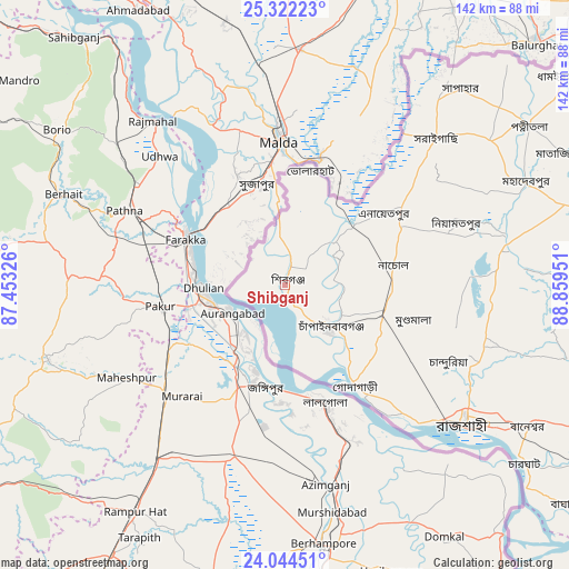
Shibganj GPS coordinates[2]
24° 41' 6.036" North, 88° 9' 22.968" East
| Map corner | latitude | longitude |
|---|---|---|
| Upper-left | 25.32223°, | 87.45326° |
| Center: | 24.68501°, | 88.15638° |
| Lower-right: | 24.04451°, | 88.85951° |
| Map W x H: | 142.1×142.1 km | = 88.3×88.3mi |
| max Lat: | 26.33338° ⇑23.9% North |
| Shibganj: | 24.68501° |
| min Lat: | ⇓76.1% South 20.85829° |
| min Long | Shibganj | max Long |
| 88.15638° | 88.15638° | 92.29773° |
| W 0%⇐ | ⇒100% E |
Elevation
Elevation of Shibganj is 30 m = 98 ft, and this is 12.1 m = 40 ft above average elevation for this country.
| Max E: |
79 m = 259 ft | 10.3% |
| Shibganj | 30 m 98 ft | |
| Avg. | 17.9 m = 59 ft | |
Min E: |
2 m = 7 ft | 89.7% |
See also: Bangladesh elevation on elevation.city.
Geographical zone
Shibganj is located in North temperate zone (between Tropic of Cancer and the Arctic Circle). Distance of this Northern Tropic circle is 138.8 km =86.2 mi to South.| Distance of | km | miles | from Shibganj |
|---|---|---|---|
| North Pole | 7262.3 | 4512.6 | to North |
| Arctic Circle | 4656.5 | 2893.4 | to North |
| Tropic Cancer | 138.8 | 86.2 | to South |
| Equator | 2744.7 | 1705.5 | to South |


Nearby cities:
15 places around Shibganj: (largest is in red/bold)
• Bherāmāra
112.1 km =69.7 mi,  130°
130°
• Bogra
124 km =77.1 mi,  81°
81°
• Dinājpur
115.4 km =71.7 mi,  24°
24°
• Ishurdi
110.9 km =68.9 mi,  123°
123°
• Joypur Hāt
99.3 km =61.7 mi,  62°
62°
• Kushtia
130.7 km =81.2 mi, 131°
• Mahasthangarh
123.6 km =76.8 mi, 75°
• Natore
89.3 km =55.5 mi,  109°
109°
• Nawābganj
15.9 km =9.9 mi, 131°
• Paharpur
91 km =56.5 mi,  65°
65°
• Puthia
77.2 km =48 mi, 117°
• Pār Naogaon
81.1 km =50.4 mi, 80°
• Rājshāhi
56.7 km =35.2 mi, 127°
• Shibganj
122.8 km =76.3 mi, 73°
• Ujalpur
108.7 km =67.5 mi,  154°
154°
Sources, notices
• [Note1] Compared only with cities in Bangladesh existing in our database
• [Src1] Map data: © OpenStreetMap contributors (CC-BY-SA)
• [Src2] Other city data from geonames.org with taken over terms of usage.
• [Src3] Geographical zone / Annual Mean Temperature by Robert A. Rohde @ Wikipedia
