Nawābganj geodata
Nawābganj (Rajshahi Division) is a populated place; located in Bangladesh in Asia/Dhaka (GMT+6) time zone. With population of 142,361 people, there are 27 cities with bigger population in this country. Compared to other cities in Bangladesh, 75.2% of cities are located further ↓South; 99.1% of cities are located further →East and 88% of cities have lower elevation than Nawābganj. Note1
Administrative division(s):
- Level 1: Rajshahi Division
- Level 2: Chapai Nababganj
- Level 3: Nawabganj Sadar Upazila
- Level 4: Paurashava


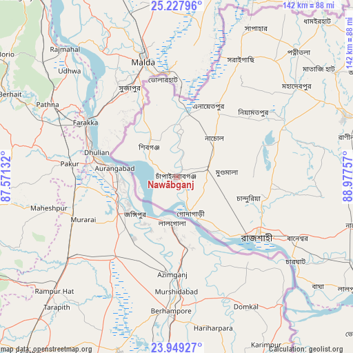
Nawābganj GPS coordinates[2]
24° 35' 24.9" North, 88° 16' 27.984" East
| Map corner | latitude | longitude |
|---|---|---|
| Upper-left | 25.22796°, | 87.57132° |
| Center: | 24.59025°, | 88.27444° |
| Lower-right: | 23.94927°, | 88.97757° |
| Map W x H: | 142.2×142.2 km | = 88.4×88.4mi |
| max Lat: | 26.33338° ⇑24.8% North |
| Nawābganj: | 24.59025° |
| min Lat: | ⇓75.2% South 20.85829° |
| min Long | Nawābganj | max Long |
| 88.15638° | 88.27444° | 92.29773° |
| W 0.9%⇐ | ⇒99.1% E |
Elevation
Elevation of Nawābganj is 28 m = 92 ft, and this is 10.1 m = 33 ft above average elevation for this country.
| Max E: |
79 m = 259 ft | 12% |
| Nawābganj | 28 m 92 ft | |
| Avg. | 17.9 m = 59 ft | |
Min E: |
2 m = 7 ft | 88% |
See also: Nawābganj elevation on elevation.city.
Geographical zone
Nawābganj is located in North temperate zone (between Tropic of Cancer and the Arctic Circle). Distance of this Northern Tropic circle is 128.3 km =79.7 mi to South.| Distance of | km | miles | from Nawābganj |
|---|---|---|---|
| North Pole | 7272.9 | 4519.2 | to North |
| Arctic Circle | 4667 | 2899.9 | to North |
| Tropic Cancer | 128.3 | 79.7 | to South |
| Equator | 2734.2 | 1699 | to South |


Nearby cities:
15 places around Nawābganj: (largest is in red/bold)
• Bherāmāra
96.2 km =59.8 mi,  130°
130°
• Bogra
114.5 km =71.1 mi,  75°
75°
• Ishurdi
95.2 km =59.2 mi,  122°
122°
• Joypur Hāt
94.9 km =59 mi,  53°
53°
• Kushtia
114.8 km =71.3 mi, 131°
• Mahasthangarh
115.5 km =71.8 mi,  69°
69°
• Natore
74.8 km =46.5 mi,  105°
105°
• Paharpur
85.8 km =53.3 mi,  55°
55°
• Puthia
61.9 km =38.5 mi, 113°
• Pābna
117.2 km =72.8 mi, 123°
• Pār Naogaon
72.2 km =44.9 mi, 70°
• Rājshāhi
40.9 km =25.4 mi, 126°
• Shibganj
15.9 km =9.9 mi,  311°
311°
• Shibganj
115.3 km =71.6 mi, 66°
• Ujalpur
94.2 km =58.5 mi,  157°
157°
Sources, notices
• [Note1] Compared only with cities in Bangladesh existing in our database
• [Src1] Map data: © OpenStreetMap contributors (CC-BY-SA)
• [Src2] Other city data from geonames.org with taken over terms of usage.
• [Src3] Geographical zone / Annual Mean Temperature by Robert A. Rohde @ Wikipedia
