Sylhet geodata
Sylhet is a seat of a first-order administrative division; located in Bangladesh in Asia/Dhaka (GMT+6) time zone. With population of 237,000 people, there are 14 cities with bigger population in this country. Compared to other cities in Bangladesh, 82.9% of cities are located further ↓South; 94% of cities are located further ←West and 84.6% of cities have lower elevation than Sylhet. Note1


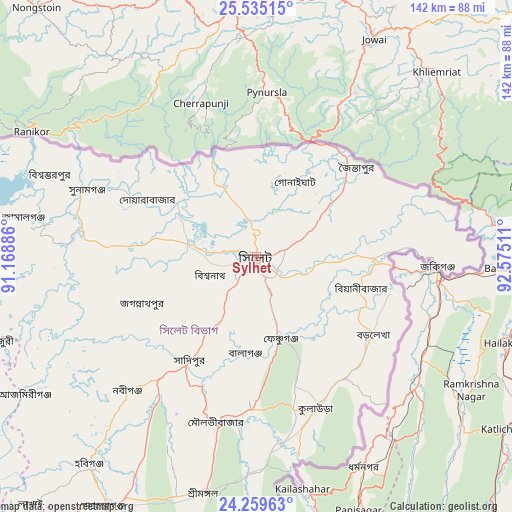
Sylhet GPS coordinates[2]
24° 53' 56.544" North, 91° 52' 19.128" East
| Map corner | latitude | longitude |
|---|---|---|
| Upper-left | 25.53515°, | 91.16886° |
| Center: | 24.89904°, | 91.87198° |
| Lower-right: | 24.25963°, | 92.57511° |
| Map W x H: | 141.8×141.8 km | = 88.1×88.1mi |
| max Lat: | 26.33338° ⇑17.1% North |
| Sylhet: | 24.89904° |
| min Lat: | ⇓82.9% South 20.85829° |
| min Long | Sylhet | max Long |
| 88.15638° | 91.87198° | 92.29773° |
| W 94%⇐ | ⇒6% E |
Elevation
Elevation of Sylhet is 26 m = 85 ft, and this is 8.1 m = 27 ft above average elevation for this country.
| Max E: |
79 m = 259 ft | 15.4% |
| Sylhet | 26 m 85 ft | |
| Avg. | 17.9 m = 59 ft | |
Min E: |
2 m = 7 ft | 84.6% |
See also: Sylhet elevation on elevation.city.
Geographical zone
Sylhet is located in North temperate zone (between Tropic of Cancer and the Arctic Circle). Distance of this Northern Tropic circle is 162.6 km =101 mi to South.| Distance of | km | miles | from Sylhet |
|---|---|---|---|
| North Pole | 7238.5 | 4497.8 | to North |
| Arctic Circle | 4632.7 | 2878.6 | to North |
| Tropic Cancer | 162.6 | 101 | to South |
| Equator | 2768.5 | 1720.3 | to South |


Nearby cities:
15 places around Sylhet: (largest is in red/bold)
• Baniachang
67 km =41.6 mi,  230°
230°
• Bhairab Bāzār
130.7 km =81.2 mi,  223°
223°
• Bājitpur
120.2 km =74.7 mi, 230°
• Chhātak
25.6 km =15.9 mi,  307°
307°
• Gafargaon
142.5 km =88.5 mi,  248°
248°
• Habiganj
74 km =46 mi, 218°
• Jahedpur
23.6 km =14.7 mi, 251°
• Kishorganj
121.3 km =75.4 mi, 245°
• Maulavi Bāzār
46.7 km =29 mi,  192°
192°
• Muktāgācha
163.6 km =101.7 mi,  264°
264°
• Mymensingh
148.7 km =92.4 mi, 263°
• Nabīnagar
145 km =90.1 mi, 219°
• Narsingdi
159.5 km =99.1 mi, 227°
• Netrakona
115.3 km =71.6 mi,  269°
269°
• Purbadhala
128.3 km =79.7 mi, 272°
Sources, notices
• [Note1] Compared only with cities in Bangladesh existing in our database
• [Src1] Map data: © OpenStreetMap contributors (CC-BY-SA)
• [Src2] Other city data from geonames.org with taken over terms of usage.
• [Src3] Geographical zone / Annual Mean Temperature by Robert A. Rohde @ Wikipedia
