Jahedpur geodata
Jahedpur (Sylhet) is a populated place; located in Bangladesh in Asia/Dhaka (GMT+6) time zone. With population of 3,000 people, there are 110 cities with bigger population in this country. Compared to other cities in Bangladesh, 80.3% of cities are located further ↓South; 88.9% of cities are located further ←West and 88.9% of cities have higher elevation than Jahedpur. Note1
Administrative division(s):
- Level 1: Sylhet
- Level 2: Sunamganj
- Level 3: Chhatak
- Level 4: Dular Bazar


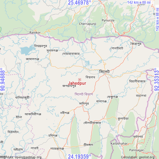
Jahedpur GPS coordinates[2]
24° 49' 59.988" North, 91° 39' 0" East
| Map corner | latitude | longitude |
|---|---|---|
| Upper-left | 25.46978°, | 90.94688° |
| Center: | 24.83333°, | 91.65° |
| Lower-right: | 24.19359°, | 92.35313° |
| Map W x H: | 141.9×141.9 km | = 88.2×88.2mi |
| max Lat: | 26.33338° ⇑19.7% North |
| Jahedpur: | 24.83333° |
| min Lat: | ⇓80.3% South 20.85829° |
| min Long | Jahedpur | max Long |
| 88.15638° | 91.65° | 92.29773° |
| W 88.9%⇐ | ⇒11.1% E |
Elevation
Elevation of Jahedpur is 9 m = 30 ft, and this is 8.9 m = 29 ft below average elevation for this country.
| Max E: |
79 m = 259 ft | 88.9% |
| Avg. | 17.9 m = 59 ft | |
| Jahedpur | 9 m = 30 ft | |
Min E: |
2 m = 7 ft | 11.1% |
See also: Bangladesh elevation on elevation.city.
Geographical zone
Jahedpur is located in North temperate zone (between Tropic of Cancer and the Arctic Circle). Distance of this Northern Tropic circle is 155.3 km =96.5 mi to South.| Distance of | km | miles | from Jahedpur |
|---|---|---|---|
| North Pole | 7245.9 | 4502.4 | to North |
| Arctic Circle | 4640 | 2883.2 | to North |
| Tropic Cancer | 155.3 | 96.5 | to South |
| Equator | 2761.2 | 1715.7 | to South |


Nearby cities:
15 places around Jahedpur: (largest is in red/bold)
• Baniachang
45.8 km =28.5 mi,  220°
220°
• Bhairab Bāzār
110.4 km =68.6 mi, 218°
• Bājitpur
98.6 km =61.3 mi,  225°
225°
• Chhātak
22.9 km =14.2 mi,  4°
4°
• Gafargaon
119 km =73.9 mi,  247°
247°
• Habiganj
55.8 km =34.7 mi,  205°
205°
• Kishorganj
98 km =60.9 mi,  243°
243°
• Maulavi Bāzār
40.2 km =25 mi,  162°
162°
• Muktāgācha
140.8 km =87.5 mi,  266°
266°
• Mymensingh
125.8 km =78.2 mi, 266°
• Nabīnagar
125.8 km =78.2 mi, 213°
• Narsingdi
138.4 km =86 mi, 223°
• Netrakona
93.1 km =57.8 mi, 273°
• Purbadhala
106.6 km =66.2 mi,  276°
276°
• Sylhet
23.6 km =14.7 mi,  71°
71°
Sources, notices
• [Note1] Compared only with cities in Bangladesh existing in our database
• [Src1] Map data: © OpenStreetMap contributors (CC-BY-SA)
• [Src2] Other city data from geonames.org with taken over terms of usage.
• [Src3] Geographical zone / Annual Mean Temperature by Robert A. Rohde @ Wikipedia
