Patiya geodata
Patiya (Chittagong) is a populated place; located in Bangladesh in Asia/Dhaka (GMT+6) time zone. With population of 51,360 people, there are 61 cities with bigger population in this country. Compared to other cities in Bangladesh, 94.9% of cities are located further ↑North; 96.6% of cities are located further ←West and 76.1% of cities have higher elevation than Patiya. Note1
Administrative division(s):
- Level 1: Chittagong
- Level 2: Chittagong
- Level 3: Patiya Upazila
- Level 4: Paurashava


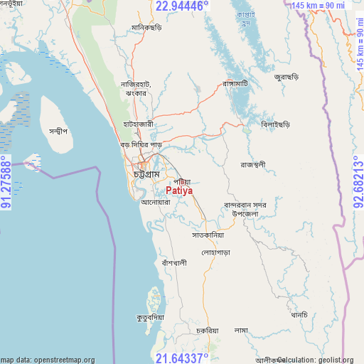
Patiya GPS coordinates[2]
22° 17' 43.548" North, 91° 58' 44.4" East
| Map corner | latitude | longitude |
|---|---|---|
| Upper-left | 22.94446°, | 91.27588° |
| Center: | 22.29543°, | 91.979° |
| Lower-right: | 21.64337°, | 92.68213° |
| Map W x H: | 144.7×144.7 km | = 89.9×89.9mi |
| max Lat: | 26.33338° ⇑94.9% North |
| Patiya: | 22.29543° |
| min Lat: | ⇓5.1% South 20.85829° |
| min Long | Patiya | max Long |
| 88.15638° | 91.979° | 92.29773° |
| W 96.6%⇐ | ⇒3.4% E |
Elevation
Elevation of Patiya is 11 m = 36 ft, and this is 6.9 m = 23 ft below average elevation for this country.
| Max E: |
79 m = 259 ft | 76.1% |
| Avg. | 17.9 m = 59 ft | |
| Patiya | 11 m = 36 ft | |
Min E: |
2 m = 7 ft | 23.9% |
See also: Patiya elevation on elevation.city.
Geographical zone
Patiya is located in North Torrid zone (between Equator and Tropic of Cancer). Distance of this Northern Tropic circle is 126.9 km =78.9 mi to North.| Distance of | km | miles | from Patiya |
|---|---|---|---|
| North Pole | 7528 | 4677.7 | to North |
| Arctic Circle | 4922.2 | 3058.5 | to North |
| Tropic Cancer | 126.9 | 78.9 | to North |
| Equator | 2479 | 1540.4 | to South |


Nearby cities:
15 places around Patiya: (largest is in red/bold)
• Bibir Hat
47.3 km =29.4 mi,  335°
335°
• Burhānuddin
130.9 km =81.3 mi,  279°
279°
• Bāndarban
27.1 km =16.8 mi,  114°
114°
• Chhāgalnāiya
94.2 km =58.5 mi,  329°
329°
• Chittagong
15.9 km =9.9 mi,  287°
287°
• Cox’s Bāzār
95.2 km =59.2 mi,  178°
178°
• Feni
99.8 km =62 mi,  323°
323°
• Khagrachhari
90.3 km =56.1 mi,  359°
359°
• Lākshām
137 km =85.1 mi, 320°
• Lālmohan
127.8 km =79.4 mi,  272°
272°
• Manikchari
62.1 km =38.6 mi,  346°
346°
• Raojān
27.3 km =17 mi, 347°
• Sandwīp
59.1 km =36.7 mi, 294°
• Sātkania
25.4 km =15.8 mi,  163°
163°
• Uttar Char Fasson
130.5 km =81.1 mi, 266°
Sources, notices
• [Note1] Compared only with cities in Bangladesh existing in our database
• [Src1] Map data: © OpenStreetMap contributors (CC-BY-SA)
• [Src2] Other city data from geonames.org with taken over terms of usage.
• [Src3] Geographical zone / Annual Mean Temperature by Robert A. Rohde @ Wikipedia
