Lālmohan geodata
Lālmohan (Barisāl) is a populated place; located in Bangladesh in Asia/Dhaka (GMT+6) time zone. With population of 42,220 people, there are 73 cities with bigger population in this country. Compared to other cities in Bangladesh, 93.2% of cities are located further ↑North; 75.2% of cities are located further ←West and 81.2% of cities have higher elevation than Lālmohan. Note1


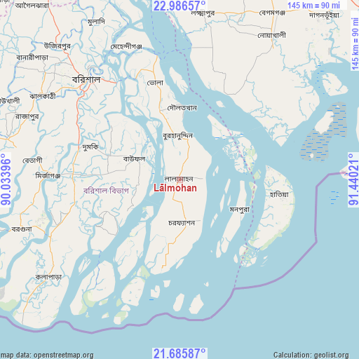
Lālmohan GPS coordinates[2]
22° 20' 15.864" North, 90° 44' 13.488" East
| Map corner | latitude | longitude |
|---|---|---|
| Upper-left | 22.98657°, | 90.03396° |
| Center: | 22.33774°, | 90.73708° |
| Lower-right: | 21.68587°, | 91.44021° |
| Map W x H: | 144.6×144.6 km | = 89.9×89.9mi |
| max Lat: | 26.33338° ⇑93.2% North |
| Lālmohan: | 22.33774° |
| min Lat: | ⇓6.8% South 20.85829° |
| min Long | Lālmohan | max Long |
| 88.15638° | 90.73708° | 92.29773° |
| W 75.2%⇐ | ⇒24.8% E |
Elevation
Elevation of Lālmohan is 10 m = 33 ft, and this is 7.9 m = 26 ft below average elevation for this country.
| Max E: |
79 m = 259 ft | 81.2% |
| Avg. | 17.9 m = 59 ft | |
| Lālmohan | 10 m = 33 ft | |
Min E: |
2 m = 7 ft | 18.8% |
See also: Lālmohan elevation on elevation.city.
Geographical zone
Lālmohan is located in North Torrid zone (between Equator and Tropic of Cancer). Distance of this Northern Tropic circle is 122.2 km =75.9 mi to North.| Distance of | km | miles | from Lālmohan |
|---|---|---|---|
| North Pole | 7523.3 | 4674.8 | to North |
| Arctic Circle | 4917.5 | 3055.6 | to North |
| Tropic Cancer | 122.2 | 75.9 | to North |
| Equator | 2483.7 | 1543.3 | to South |


Nearby cities:
15 places around Lālmohan: (largest is in red/bold)
• Barisāl
55.6 km =34.5 mi,  317°
317°
• Bhola
40.1 km =24.9 mi,  346°
346°
• Bhāndāria
71.3 km =44.3 mi,  283°
283°
• Burhānuddin
17.6 km =10.9 mi,  355°
355°
• Gaurnadi
88.2 km =54.8 mi, 323°
• Lakshmīpur
68.1 km =42.3 mi,  8°
8°
• Mathba
80.3 km =49.9 mi,  265°
265°
• Mehendiganj
58 km =36 mi,  338°
338°
• Morrelgonj
91.5 km =56.9 mi, 278°
• Nālchiti
58.2 km =36.2 mi,  304°
304°
• Pirojpur
82.8 km =51.4 mi,  288°
288°
• Rāipur
78 km =48.5 mi,  2°
2°
• Rāmganj
85.6 km =53.2 mi, 7°
• Sandwīp
76.3 km =47.4 mi,  75°
75°
• Uttar Char Fasson
12.6 km =7.8 mi,  191°
191°
Sources, notices
• [Note1] Compared only with cities in Bangladesh existing in our database
• [Src1] Map data: © OpenStreetMap contributors (CC-BY-SA)
• [Src2] Other city data from geonames.org with taken over terms of usage.
• [Src3] Geographical zone / Annual Mean Temperature by Robert A. Rohde @ Wikipedia
