Westerlo geodata
Westerlo (Flanders) is a populated place; located in Belgium in Europe/Brussels (GMT+2) time zone. With population of 22,579 people, there are 96 cities with bigger population in this country. Compared to other cities in Belgium, 79.2% of cities are located further ↓South; 63% of cities are located further ←West and 79.4% of cities have higher elevation than Westerlo. Note1
Administrative division(s):
- Level 1: Flanders
- Level 2: Provincie Antwerpen
- Level 3: Arrondissement Turnhout
- Level 4: Westerlo


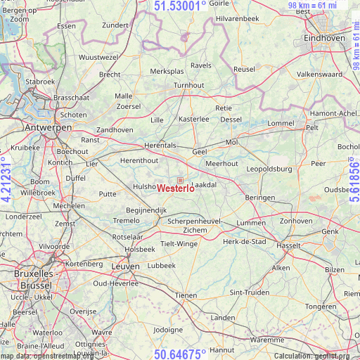
Westerlo GPS coordinates[2]
51° 5' 25.764" North, 4° 54' 55.584" East
| Map corner | latitude | longitude |
|---|---|---|
| Upper-left | 51.53001°, | 4.21231° |
| Center: | 51.09049°, | 4.91544° |
| Lower-right: | 50.64675°, | 5.61856° |
| Map W x H: | 98.2×98.2 km | = 61×61mi |
| max Lat: | 51.46791° ⇑20.8% North |
| Westerlo: | 51.09049° |
| min Lat: | ⇓79.2% South 49.53771° |
| min Long | Westerlo | max Long |
| 2.59368° | 4.91544° | 6.25749° |
| W 63%⇐ | ⇒37% E |
Elevation
Elevation of Westerlo is 14 m = 46 ft, and this is 85.5 m = 281 ft below average elevation for this country.
| Max E: |
582 m = 1909 ft | 79.4% |
| Avg. | 99.5 m = 326 ft | |
| Westerlo | 14 m = 46 ft | |
Min E: |
1 m = 3 ft | 20.6% |
See also: Belgium elevation on elevation.city.
Geographical zone
Westerlo is located in North temperate zone (between Tropic of Cancer and the Arctic Circle). Distance of this North polar circle is 1720.4 km =1069 mi to North.| Distance of | km | miles | from Westerlo |
|---|---|---|---|
| North Pole | 4326.3 | 2688.2 | to North |
| Arctic Circle | 1720.4 | 1069 | to North |
| Tropic Cancer | 3074.8 | 1910.6 | to South |
| Equator | 5680.7 | 3529.8 | to South |


Nearby cities:
15 places around Westerlo: (largest is in red/bold)
• Aarschot
12.7 km =7.9 mi,  205°
205°
• Begijnendijk
12.1 km =7.5 mi,  229°
229°
• Diest
14.7 km =9.1 mi,  139°
139°
• Geel
9.8 km =6.1 mi,  31°
31°
• Heist-op-den-Berg
13.2 km =8.2 mi,  262°
262°
• Herentals
11.2 km =7 mi,  328°
328°
• Herenthout
12.4 km =7.7 mi,  296°
296°
• Herselt
4.9 km =3 mi, 208°
• Hulshout
8.9 km =5.5 mi, 258°
• Laakdal
6.4 km =4 mi,  99°
99°
• Meerhout
12.3 km =7.6 mi,  67°
67°
• Olen
7.1 km =4.4 mi, 326°
• Scherpenheuvel-Zichem
9.8 km =6.1 mi,  154°
154°
• Tessenderlo
12.4 km =7.7 mi, 103°
• Vorselaar
15.9 km =9.9 mi,  321°
321°
Sources, notices
• [Note1] Compared only with cities in Belgium existing in our database
• [Src1] Map data: © OpenStreetMap contributors (CC-BY-SA)
• [Src2] Other city data from geonames.org with taken over terms of usage.
• [Src3] Geographical zone / Annual Mean Temperature by Robert A. Rohde @ Wikipedia
