Laakdal geodata
Laakdal (Flanders) is a seat of a fourth-order administrative division; located in Belgium in Europe/Brussels (GMT+2) time zone. In our database, there are 548 cities with bigger population. Compared to other cities in Belgium, 78.5% of cities are located further ↓South; 66.2% of cities are located further ←West and 74.9% of cities have higher elevation than Laakdal. Note1
Administrative division(s):
- Level 1: Flanders
- Level 2: Provincie Antwerpen
- Level 3: Arrondissement Turnhout
- Level 4: Laakdal


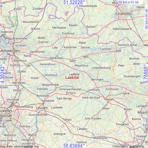
Laakdal GPS coordinates[2]
51° 4' 50.412" North, 5° 0' 20.016" East
| Map corner | latitude | longitude |
|---|---|---|
| Upper-left | 51.52028°, | 4.30243° |
| Center: | 51.08067°, | 5.00556° |
| Lower-right: | 50.63684°, | 5.70868° |
| Map W x H: | 98.2×98.2 km | = 61×61mi |
| max Lat: | 51.46791° ⇑21.5% North |
| Laakdal: | 51.08067° |
| min Lat: | ⇓78.5% South 49.53771° |
| min Long | Laakdal | max Long |
| 2.59368° | 5.00556° | 6.25749° |
| W 66.2%⇐ | ⇒33.8% E |
Elevation
Elevation of Laakdal is 18 m = 59 ft, and this is 81.5 m = 267 ft below average elevation for this country.
| Max E: |
582 m = 1909 ft | 74.9% |
| Avg. | 99.5 m = 326 ft | |
| Laakdal | 18 m = 59 ft | |
Min E: |
1 m = 3 ft | 25.1% |
See also: Belgium elevation on elevation.city.
Geographical zone
Laakdal is located in North temperate zone (between Tropic of Cancer and the Arctic Circle). Distance of this North polar circle is 1721.5 km =1069.7 mi to North.| Distance of | km | miles | from Laakdal |
|---|---|---|---|
| North Pole | 4327.4 | 2688.9 | to North |
| Arctic Circle | 1721.5 | 1069.7 | to North |
| Tropic Cancer | 3073.7 | 1909.9 | to South |
| Equator | 5679.6 | 3529.1 | to South |


Nearby cities:
15 places around Laakdal: (largest is in red/bold)
• Aarschot
15.7 km =9.8 mi,  228°
228°
• Balen
15.1 km =9.4 mi,  49°
49°
• Bekkevoort
15.8 km =9.8 mi,  189°
189°
• Beringen
15.8 km =9.8 mi,  102°
102°
• Diest
10.6 km =6.6 mi,  162°
162°
• Geel
9.5 km =5.9 mi,  353°
353°
• Herentals
16.1 km =10 mi,  311°
311°
• Herselt
9.2 km =5.7 mi,  249°
249°
• Hulshout
15 km =9.3 mi,  267°
267°
• Meerhout
7.7 km =4.8 mi,  41°
41°
• Mol
14.6 km =9.1 mi,  32°
32°
• Olen
12.4 km =7.7 mi,  304°
304°
• Scherpenheuvel-Zichem
8.1 km =5 mi,  195°
195°
• Tessenderlo
6.1 km =3.8 mi,  106°
106°
• Westerlo
6.4 km =4 mi,  279°
279°
Sources, notices
• [Note1] Compared only with cities in Belgium existing in our database
• [Src1] Map data: © OpenStreetMap contributors (CC-BY-SA)
• [Src2] Other city data from geonames.org with taken over terms of usage.
• [Src3] Geographical zone / Annual Mean Temperature by Robert A. Rohde @ Wikipedia
