Leopoldsburg geodata
Leopoldsburg (Flanders) is a populated place; located in Belgium in Europe/Brussels (GMT+2) time zone. With population of 14,149 people, there are 203 cities with bigger population in this country. Compared to other cities in Belgium, 82.1% of cities are located further ↓South; 74.9% of cities are located further ←West and 50.9% of cities have higher elevation than Leopoldsburg. Note1
Administrative division(s):
- Level 1: Flanders
- Level 2: Provincie Limburg
- Level 3: Arrondissement Hasselt
- Level 4: Leopoldsburg


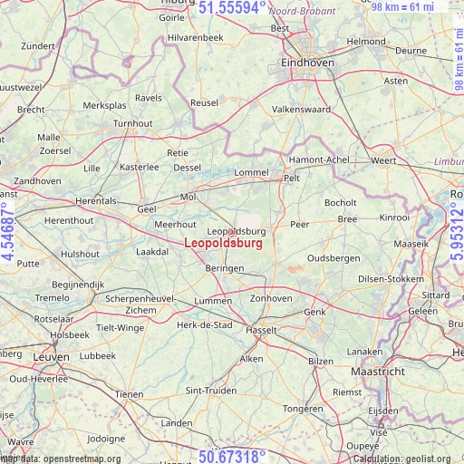
Leopoldsburg GPS coordinates[2]
51° 7' 0.012" North, 5° 15' 0" East
| Map corner | latitude | longitude |
|---|---|---|
| Upper-left | 51.55594°, | 4.54687° |
| Center: | 51.11667°, | 5.25° |
| Lower-right: | 50.67318°, | 5.95312° |
| Map W x H: | 98.2×98.2 km | = 61×61mi |
| max Lat: | 51.46791° ⇑17.9% North |
| Leopoldsburg: | 51.11667° |
| min Lat: | ⇓82.1% South 49.53771° |
| min Long | Leopoldsburg | max Long |
| 2.59368° | 5.25° | 6.25749° |
| W 74.9%⇐ | ⇒25.1% E |
Elevation
Elevation of Leopoldsburg is 48 m = 157 ft, and this is 51.5 m = 169 ft below average elevation for this country.
| Max E: |
582 m = 1909 ft | 50.9% |
| Avg. | 99.5 m = 326 ft | |
| Leopoldsburg | 48 m = 157 ft | |
Min E: |
1 m = 3 ft | 49.1% |
See also: Belgium elevation on elevation.city.
Geographical zone
Leopoldsburg is located in North temperate zone (between Tropic of Cancer and the Arctic Circle). Distance of this North polar circle is 1717.5 km =1067.2 mi to North.| Distance of | km | miles | from Leopoldsburg |
|---|---|---|---|
| North Pole | 4323.4 | 2686.4 | to North |
| Arctic Circle | 1717.5 | 1067.2 | to North |
| Tropic Cancer | 3077.7 | 1912.4 | to South |
| Equator | 5683.6 | 3531.6 | to South |


Nearby cities:
15 places around Leopoldsburg: (largest is in red/bold)
• Balen
8 km =5 mi,  315°
315°
• Beringen
7.6 km =4.7 mi,  192°
192°
• Dessel
16.5 km =10.3 mi,  325°
325°
• Helchteren
11.5 km =7.1 mi,  126°
126°
• Heusden
9.1 km =5.7 mi,  166°
166°
• Houthalen
12.6 km =7.8 mi,  136°
136°
• Laakdal
17.5 km =10.9 mi,  256°
256°
• Lommel
13.4 km =8.3 mi,  19°
19°
• Lummen
14.9 km =9.3 mi,  195°
195°
• Meerhout
12.1 km =7.5 mi,  278°
278°
• Mol
12.5 km =7.8 mi,  311°
311°
• Overpelt
15.6 km =9.7 mi,  47°
47°
• Peer
14.7 km =9.1 mi,  84°
84°
• Tessenderlo
12.6 km =7.8 mi,  243°
243°
• Zonhoven
16.3 km =10.1 mi,  149°
149°
Sources, notices
• [Note1] Compared only with cities in Belgium existing in our database
• [Src1] Map data: © OpenStreetMap contributors (CC-BY-SA)
• [Src2] Other city data from geonames.org with taken over terms of usage.
• [Src3] Geographical zone / Annual Mean Temperature by Robert A. Rohde @ Wikipedia
