Dédougou geodata
Dédougou (Boucle du Mouhoun) is a seat of a first-order administrative division; located in Burkina Faso in Africa/Ouagadougou (GMT+0) time zone. With population of 45,341 people, there are 5 cities with bigger population in this country. Compared to other cities in Burkina Faso, 51.9% of cities are located further ↑North; 91.1% of cities are located further →East and 53.2% of cities have higher elevation than Dédougou. Note1


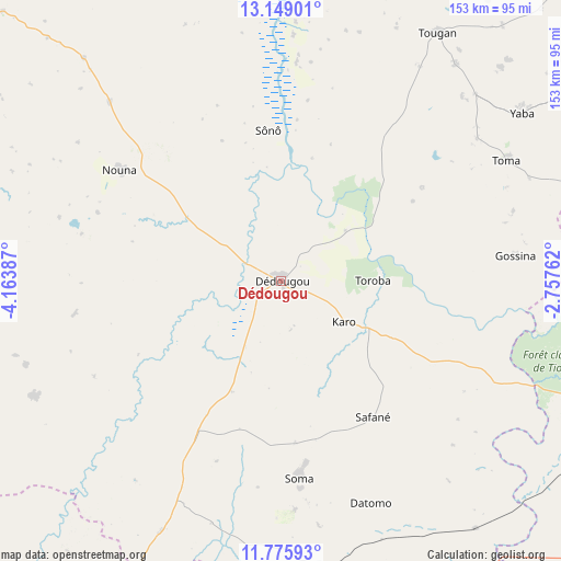
Dédougou GPS coordinates[2]
12° 27' 48.168" North, 3° 27' 38.7" West
| Map corner | latitude | longitude |
|---|---|---|
| Upper-left | 13.14901°, | -4.16387° |
| Center: | 12.46338°, | -3.46075° |
| Lower-right: | 11.77593°, | -2.75762° |
| Map W x H: | 152.7×152.7 km | = 94.9×94.9mi |
| max Lat: | 14.96549° ⇑51.9% North |
| Dédougou: | 12.46338° |
| min Lat: | ⇓48.1% South 9.88333° |
| min Long | Dédougou | max Long |
| -5.16667° | -3.46075° | 1.78838° |
| W 8.9%⇐ | ⇒91.1% E |
Elevation
Elevation of Dédougou is 302 m = 991 ft, and this is 1 m = 3 ft below average elevation for this country.
| Max E: |
423 m = 1388 ft | 53.2% |
| Avg. | 303 m = 994 ft | |
| Dédougou | 302 m = 991 ft | |
Min E: |
222 m = 728 ft | 46.8% |
See also: Dédougou elevation on elevation.city.
Geographical zone
Dédougou is located in North Torrid zone (between Equator and Tropic of Cancer). Distance of this Northern Tropic circle is 1220.1 km =758.1 mi to North.| Distance of | km | miles | from Dédougou |
|---|---|---|---|
| North Pole | 8621.3 | 5357 | to North |
| Arctic Circle | 6015.4 | 3737.8 | to North |
| Tropic Cancer | 1220.1 | 758.1 | to North |
| Equator | 1385.8 | 861.1 | to South |


Nearby cities:
15 places around Dédougou: (largest is in red/bold)
• Barani
91.2 km =56.7 mi,  329°
329°
• Boromo
98.5 km =61.2 mi,  144°
144°
• Dano
152.9 km =95 mi,  163°
163°
• Gourcy
145.3 km =90.3 mi,  55°
55°
• Gousi
75.3 km =46.8 mi,  73°
73°
• Houndé
107.3 km =66.7 mi,  183°
183°
• Koudougou
121.5 km =75.5 mi,  101°
101°
• Nouna
52.7 km =32.7 mi,  304°
304°
• Ouahigouya
167.8 km =104.3 mi,  42°
42°
• Réo
108.7 km =67.5 mi, 98°
• Salanso
75 km =46.6 mi,  244°
244°
• Sièn
66.1 km =41.1 mi, 67°
• Toma
69.2 km =43 mi, 61°
• Tougan
79.9 km =49.6 mi,  32°
32°
• Yako
141.3 km =87.8 mi, 67°
Sources, notices
• [Note1] Compared only with cities in Burkina Faso existing in our database
• [Src1] Map data: © OpenStreetMap contributors (CC-BY-SA)
• [Src2] Other city data from geonames.org with taken over terms of usage.
• [Src3] Geographical zone / Annual Mean Temperature by Robert A. Rohde @ Wikipedia
