Houndé geodata
Houndé (Hauts-Bassins) is a seat of a second-order administrative division; located in Burkina Faso in Africa/Ouagadougou (GMT+0) time zone. With population of 36,593 people, there are 10 cities with bigger population in this country. Compared to other cities in Burkina Faso, 88.6% of cities are located further ↑North; 92.4% of cities are located further →East and 96.2% of cities have lower elevation than Houndé. Note1


Houndé GPS coordinates[2]
11° 30' 0" North, 3° 31' 0.012" West
| Map corner | latitude | longitude |
|---|---|---|
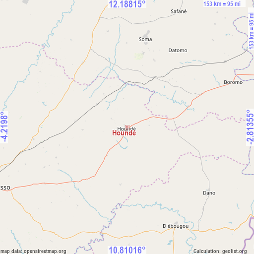
| Upper-left | 12.18815°, | -4.2198° |
| Center: | 11.5°, | -3.51667° |
| Lower-right: | 10.81016°, | -2.81355° |
| Map W x H: | 153.2×153.2 km | = 95.2×95.2mi |
| max Lat: | 14.96549° ⇑88.6% North |
| Houndé: | 11.5° |
| min Lat: | ⇓11.4% South 9.88333° |
| min Long | Houndé | max Long |
| -5.16667° | -3.51667° | 1.78838° |
| W 7.6%⇐ | ⇒92.4% E |
Elevation
Elevation of Houndé is 349 m = 1145 ft, and this is 46 m = 151 ft above average elevation for this country.
| Max E: |
423 m = 1388 ft | 3.8% |
| Houndé | 349 m 1145 ft | |
| Avg. | 303 m = 994 ft | |
Min E: |
222 m = 728 ft | 96.2% |
See also: Burkina Faso elevation on elevation.city.
Geographical zone
Houndé is located in North Torrid zone (between Equator and Tropic of Cancer). Distance of Equator is 1278.7 km =794.5 mi to South.| Distance of | km | miles | from Houndé |
|---|---|---|---|
| North Pole | 8728.4 | 5423.6 | to North |
| Arctic Circle | 6122.5 | 3804.3 | to North |
| Tropic Cancer | 1327.2 | 824.7 | to North |
| Equator | 1278.7 | 794.5 | to South |


Nearby cities:
15 places around Houndé: (largest is in red/bold)
• Banfora
167 km =103.8 mi,  234°
234°
• Bobo-Dioulasso
92.4 km =57.4 mi,  247°
247°
• Boromo
69.5 km =43.2 mi,  66°
66°
• Dano
63.6 km =39.5 mi,  128°
128°
• Diébougou
66.5 km =41.3 mi,  154°
154°
• Dédougou
107.3 km =66.7 mi,  3°
3°
• Gousi
150.6 km =93.6 mi,  31°
31°
• Koudougou
150.9 km =93.8 mi,  56°
56°
• Léo
160 km =99.4 mi,  106°
106°
• Nouna
141.8 km =88.1 mi,  344°
344°
• Réo
145.8 km =90.6 mi,  51°
51°
• Salanso
97.2 km =60.4 mi,  320°
320°
• Sièn
148.7 km =92.4 mi, 26°
• Toma
155.2 km =96.4 mi, 25°
• Tougan
181.5 km =112.8 mi,  15°
15°
Sources, notices
• [Note1] Compared only with cities in Burkina Faso existing in our database
• [Src1] Map data: © OpenStreetMap contributors (CC-BY-SA)
• [Src2] Other city data from geonames.org with taken over terms of usage.
• [Src3] Geographical zone / Annual Mean Temperature by Robert A. Rohde @ Wikipedia
