Kandi geodata
Kandi (Alibori) is a seat of a first-order administrative division; located in Benin in Africa/Porto-Novo (GMT+1) time zone. With population of 109,701 people, there are 6 cities with bigger population in this country. Compared to other cities in Benin, 91.3% of cities are located further ↓South; 93.5% of cities are located further ←West and 76.1% of cities have lower elevation than Kandi. Note1


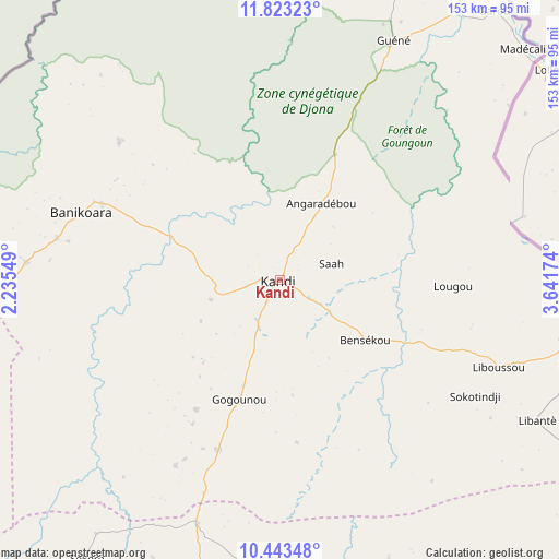
Kandi GPS coordinates[2]
11° 8' 3.012" North, 2° 56' 18.996" East
| Map corner | latitude | longitude |
|---|---|---|
| Upper-left | 11.82323°, | 2.23549° |
| Center: | 11.13417°, | 2.93861° |
| Lower-right: | 10.44348°, | 3.64174° |
| Map W x H: | 153.4×153.4 km | = 95.3×95.3mi |
| max Lat: | 11.86819° ⇑8.7% North |
| Kandi: | 11.13417° |
| min Lat: | ⇓91.3% South 6.28036° |
| min Long | Kandi | max Long |
| 1.26651° | 2.93861° | 3.38327° |
| W 93.5%⇐ | ⇒6.5% E |
Elevation
Elevation of Kandi is 294 m = 965 ft, and this is 131.2 m = 430 ft above average elevation for this country.
| Max E: |
472 m = 1549 ft | 23.9% |
| Kandi | 294 m 965 ft | |
| Avg. | 162.8 m = 534 ft | |
Min E: |
1 m = 3 ft | 76.1% |
See also: Kandi elevation on elevation.city.
Geographical zone
Kandi is located in North Torrid zone (between Equator and Tropic of Cancer). Distance of Equator is 1238 km =769.3 mi to South.| Distance of | km | miles | from Kandi |
|---|---|---|---|
| North Pole | 8769.1 | 5448.9 | to North |
| Arctic Circle | 6163.2 | 3829.6 | to North |
| Tropic Cancer | 1367.9 | 850 | to North |
| Equator | 1238 | 769.3 | to South |


Nearby cities:
15 places around Kandi: (largest is in red/bold)
• Angara-Débou
24.9 km =15.5 mi,  31°
31°
• Banikoara
57.5 km =35.7 mi,  288°
288°
• Bassila
274.4 km =170.5 mi,  210°
210°
• Bembèrèkè
105.1 km =65.3 mi,  196°
196°
• Bétérou
227.7 km =141.5 mi, 199°
• Djougou
210.9 km =131 mi,  221°
221°
• Goumori
70.6 km =43.9 mi,  274°
274°
• Guilmaro
146.9 km =91.3 mi,  244°
244°
• Malanville
94.9 km =59 mi, 30°
• Natitingou
193.7 km =120.4 mi, 241°
• Nikki
136.1 km =84.6 mi,  167°
167°
• Parakou
202.6 km =125.9 mi,  189°
189°
• Savé
348.2 km =216.4 mi, 188°
• Tanguiéta
191.3 km =118.9 mi,  252°
252°
• Tchaourou
252.7 km =157 mi, 188°
Sources, notices
• [Note1] Compared only with cities in Benin existing in our database
• [Src1] Map data: © OpenStreetMap contributors (CC-BY-SA)
• [Src2] Other city data from geonames.org with taken over terms of usage.
• [Src3] Geographical zone / Annual Mean Temperature by Robert A. Rohde @ Wikipedia
