Malanville geodata
Malanville (Alibori) is a seat of a third-order administrative division; located in Benin in Africa/Porto-Novo (GMT+1) time zone. With population of 37,117 people, there are 15 cities with bigger population in this country. Compared to other cities in Benin, 100% of cities are located further ↓South; 100% of cities are located further ←West and 60.9% of cities have lower elevation than Malanville. Note1


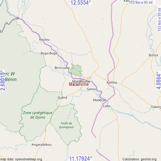
Malanville GPS coordinates[2]
11° 52' 5.484" North, 3° 22' 59.772" East
| Map corner | latitude | longitude |
|---|---|---|
| Upper-left | 12.5554°, | 2.68015° |
| Center: | 11.86819°, | 3.38327° |
| Lower-right: | 11.17924°, | 4.0864° |
| Map W x H: | 153×153 km | = 95.1×95.1mi |
| max Lat: | 11.86819° ⇑0% North |
| Malanville: | 11.86819° |
| min Lat: | ⇓100% South 6.28036° |
| min Long | Malanville | max Long |
| 1.26651° | 3.38327° | 3.38327° |
| W 100%⇐ | ⇒0% E |
Elevation
Elevation of Malanville is 164 m = 538 ft, and this is 1.2 m = 4 ft above average elevation for this country.
| Max E: |
472 m = 1549 ft | 39.1% |
| Malanville | 164 m 538 ft | |
| Avg. | 162.8 m = 534 ft | |
Min E: |
1 m = 3 ft | 60.9% |
See also: Benin elevation on elevation.city.
Geographical zone
Malanville is located in North Torrid zone (between Equator and Tropic of Cancer). Distance of this Northern Tropic circle is 1286.3 km =799.3 mi to North.| Distance of | km | miles | from Malanville |
|---|---|---|---|
| North Pole | 8687.4 | 5398.1 | to North |
| Arctic Circle | 6081.6 | 3778.9 | to North |
| Tropic Cancer | 1286.3 | 799.3 | to North |
| Equator | 1319.6 | 820 | to South |


Nearby cities:
15 places around Malanville: (largest is in red/bold)
• Angara-Débou
70 km =43.5 mi,  210°
210°
• Banikoara
120.8 km =75.1 mi,  238°
238°
• Bassila
369.3 km =229.5 mi, 210°
• Bembèrèkè
198.5 km =123.3 mi,  203°
203°
• Bétérou
321.2 km =199.6 mi, 202°
• Djougou
304.7 km =189.3 mi,  217°
217°
• Goumori
141.2 km =87.7 mi, 237°
• Guilmaro
231.7 km =144 mi,  231°
231°
• Kandi
94.9 km =59 mi, 210°
• Natitingou
279.4 km =173.6 mi, 231°
• Nikki
215.2 km =133.7 mi,  185°
185°
• Parakou
293.2 km =182.2 mi, 196°
• Savé
437.5 km =271.8 mi, 192°
• Tanguiéta
269.3 km =167.3 mi, 239°
• Tchaourou
342.5 km =212.8 mi, 194°
Sources, notices
• [Note1] Compared only with cities in Benin existing in our database
• [Src1] Map data: © OpenStreetMap contributors (CC-BY-SA)
• [Src2] Other city data from geonames.org with taken over terms of usage.
• [Src3] Geographical zone / Annual Mean Temperature by Robert A. Rohde @ Wikipedia
