San Borja geodata
San Borja (El Beni) is a populated place; located in Bolivia in America/La_Paz (GMT-4) time zone. With population of 19,640 people, there are 25 cities with bigger population in this country. Compared to other cities in Bolivia, 94.4% of cities are located further ↓South; 77.6% of cities are located further →East and 93.8% of cities have higher elevation than San Borja. Note1


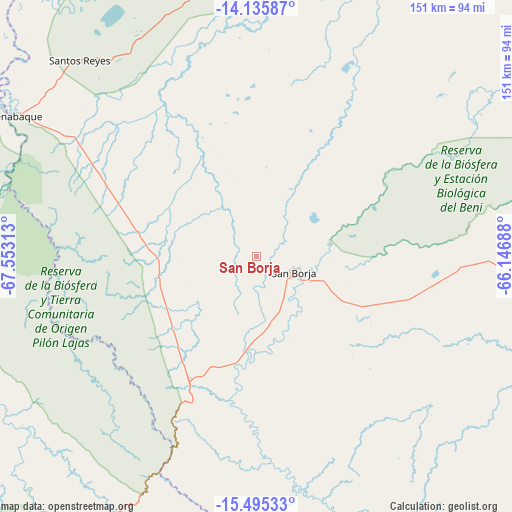
San Borja GPS coordinates[2]
14° 49' 0.012" South, 66° 51' 0" West
| Map corner | latitude | longitude |
|---|---|---|
| Upper-left | -14.13587°, | -67.55313° |
| Center: | -14.81667°, | -66.85° |
| Lower-right: | -15.49533°, | -66.14688° |
| Map W x H: | 151.2×151.2 km | = 94×94mi |
| max Lat: | -9.71828° ⇑5.6% North |
| San Borja: | -14.81667° |
| min Lat: | ⇓94.4% South -22.73206° |
| min Long | San Borja | max Long |
| -69.14843° | -66.85° | -57.76667° |
| W 22.4%⇐ | ⇒77.6% E |
Elevation
Elevation of San Borja is 191 m = 627 ft, and this is 1820.3 m = 5972 ft below average elevation for this country.
| Max E: |
4732 m = 15525 ft | 93.8% |
| Avg. | 2011.3 m = 6599 ft | |
| San Borja | 191 m = 627 ft | |
Min E: |
92 m = 302 ft | 6.2% |
See also: Bolivia elevation on elevation.city.
Geographical zone
San Borja is located in South Torrid zone (between Equator and Tropic of Capricorn). Distance of this Southern Tropic circle is 958.5 km =595.6 mi to South.| Distance of | km | miles | from San Borja |
|---|---|---|---|
| Equator | 1647.5 | 1023.7 | to North |
| Tropic Capricorn | 958.5 | 595.6 | to South |
| Antarctic Circle | 5753.7 | 3575.2 | to South |
| South Pole | 8359.6 | 5194.4 | to South |


Nearby cities:
15 places around San Borja: (largest is in red/bold)
• Achacachi
239.6 km =148.9 mi,  235°
235°
• Amarete
233.9 km =145.3 mi,  258°
258°
• Chulumani
191.4 km =118.9 mi,  202°
202°
• Coripata
183.5 km =114 mi,  205°
205°
• Coroico
179.8 km =111.7 mi, 211°
• Guanay
134.3 km =83.5 mi, 235°
• La Paz
233.2 km =144.9 mi,  216°
216°
• Mapiri
149.4 km =92.8 mi,  251°
251°
• Reyes
78.1 km =48.5 mi,  317°
317°
• Rurrenabaque
84 km =52.2 mi,  299°
299°
• San Borja
11.5 km =7.1 mi,  109°
109°
• Santa Ana de Yacuma
194.3 km =120.7 mi,  52°
52°
• Santa Rosa
72.4 km =45 mi,  357°
357°
• Sorata
220.4 km =137 mi, 241°
• Trinidad
209.6 km =130.2 mi,  90°
90°
Sources, notices
• [Note1] Compared only with cities in Bolivia existing in our database
• [Src1] Map data: © OpenStreetMap contributors (CC-BY-SA)
• [Src2] Other city data from geonames.org with taken over terms of usage.
• [Src3] Geographical zone / Annual Mean Temperature by Robert A. Rohde @ Wikipedia
