Tiahuanaco geodata
Tiahuanaco (La Paz) is a populated place; located in Bolivia in America/La_Paz (GMT-4) time zone. With population of 3,037 people, there are 83 cities with bigger population in this country. Compared to other cities in Bolivia, 79.5% of cities are located further ↓South; 95.7% of cities are located further →East and 91.3% of cities have lower elevation than Tiahuanaco. Note1


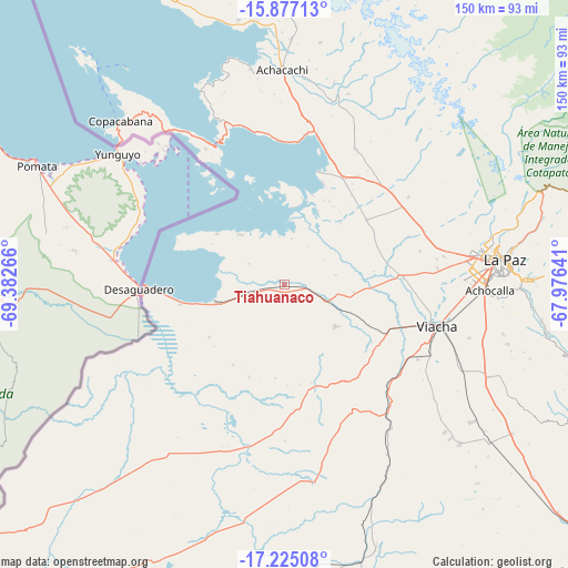
Tiahuanaco GPS coordinates[2]
16° 33' 8.208" South, 68° 40' 46.308" West
| Map corner | latitude | longitude |
|---|---|---|
| Upper-left | -15.87713°, | -69.38266° |
| Center: | -16.55228°, | -68.67953° |
| Lower-right: | -17.22508°, | -67.97641° |
| Map W x H: | 149.9×149.9 km | = 93.1×93.1mi |
| max Lat: | -9.71828° ⇑20.5% North |
| Tiahuanaco: | -16.55228° |
| min Lat: | ⇓79.5% South -22.73206° |
| min Long | Tiahuanaco | max Long |
| -69.14843° | -68.67953° | -57.76667° |
| W 4.3%⇐ | ⇒95.7% E |
Elevation
Elevation of Tiahuanaco is 3860 m = 12664 ft, and this is 1848.7 m = 6065 ft above average elevation for this country.
| Max E: |
4732 m = 15525 ft | 8.7% |
| Tiahuanaco | 3860 m 12664 ft | |
| Avg. | 2011.3 m = 6599 ft | |
Min E: |
92 m = 302 ft | 91.3% |
See also: Bolivia elevation on elevation.city.
Geographical zone
Tiahuanaco is located in South Torrid zone (between Equator and Tropic of Capricorn). Distance of this Southern Tropic circle is 765.5 km =475.7 mi to South.| Distance of | km | miles | from Tiahuanaco |
|---|---|---|---|
| Equator | 1840.4 | 1143.6 | to North |
| Tropic Capricorn | 765.5 | 475.7 | to South |
| Antarctic Circle | 5560.7 | 3455.3 | to South |
| South Pole | 8166.6 | 5074.5 | to South |


Nearby cities:
15 places around Tiahuanaco: (largest is in red/bold)
• Achacachi
55.8 km =34.7 mi,  359°
359°
• Batallas
32.1 km =19.9 mi,  29°
29°
• Chulumani
123.7 km =76.9 mi,  82°
82°
• Coripata
118.5 km =73.6 mi, 76°
• Coroico
108.9 km =67.7 mi,  68°
68°
• Huarina
39.5 km =24.5 mi,  7°
7°
• Huatajata
39.2 km =24.4 mi, 359°
• La Paz
56.7 km =35.2 mi, 84°
• Lahuachaca
140.3 km =87.2 mi,  130°
130°
• Patacamaya
110.8 km =68.8 mi, 133°
• San Pablo
40.8 km =25.4 mi,  336°
336°
• San Pedro
39.5 km =24.5 mi,  332°
332°
• Sorata
86.7 km =53.9 mi,  2°
2°
• Viloco
128.1 km =79.6 mi,  110°
110°
• Yumani
76.2 km =47.3 mi,  318°
318°
Sources, notices
• [Note1] Compared only with cities in Bolivia existing in our database
• [Src1] Map data: © OpenStreetMap contributors (CC-BY-SA)
• [Src2] Other city data from geonames.org with taken over terms of usage.
• [Src3] Geographical zone / Annual Mean Temperature by Robert A. Rohde @ Wikipedia
