La Paz geodata
La Paz is a seat of government of a political entity; located in Bolivia in America/La_Paz (GMT-4) time zone. With population of 812,799 people, there are 2 cities with bigger population in this country. Compared to other cities in Bolivia, 80.1% of cities are located further ↓South; 90.7% of cities are located further →East and 87% of cities have lower elevation than La Paz. Note1


La Paz GPS coordinates[2]
16° 30' 0" South, 68° 9' 0" West
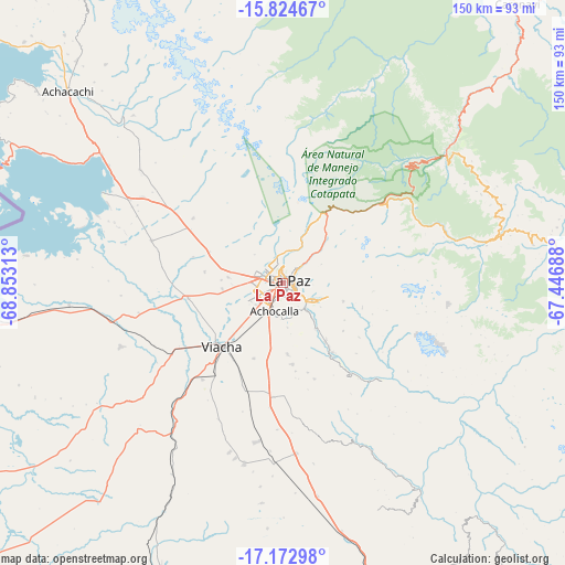
| Map corner | latitude | longitude |
|---|---|---|
| Upper-left | -15.82467°, | -68.85313° |
| Center: | -16.5°, | -68.15° |
| Lower-right: | -17.17298°, | -67.44688° |
| Map W x H: | 149.9×149.9 km | = 93.1×93.1mi |
| max Lat: | -9.71828° ⇑19.9% North |
| La Paz: | -16.5° |
| min Lat: | ⇓80.1% South -22.73206° |
| min Long | La Paz | max Long |
| -69.14843° | -68.15° | -57.76667° |
| W 9.3%⇐ | ⇒90.7% E |
Elevation
Elevation of La Paz is 3782 m = 12408 ft, and this is 1770.7 m = 5809 ft above average elevation for this country.
| Max E: |
4732 m = 15525 ft | 13% |
| La Paz | 3782 m 12408 ft | |
| Avg. | 2011.3 m = 6599 ft | |
Min E: |
92 m = 302 ft | 87% |
See also: La Paz elevation on elevation.city.
Geographical zone
La Paz is located in South Torrid zone (between Equator and Tropic of Capricorn). Distance of this Southern Tropic circle is 771.3 km =479.3 mi to South.| Distance of | km | miles | from La Paz |
|---|---|---|---|
| Equator | 1834.6 | 1140 | to North |
| Tropic Capricorn | 771.3 | 479.3 | to South |
| Antarctic Circle | 5566.5 | 3458.9 | to South |
| South Pole | 8172.4 | 5078.1 | to South |


Nearby cities:
15 places around La Paz: (largest is in red/bold)
• Achacachi
75.8 km =47.1 mi,  311°
311°
• Batallas
46.5 km =28.9 mi,  298°
298°
• Chulumani
67 km =41.6 mi,  81°
81°
• Coripata
62.7 km =39 mi,  69°
69°
• Coroico
56.3 km =35 mi,  52°
52°
• Huarina
61.4 km =38.2 mi, 302°
• Huatajata
66 km =41 mi, 300°
• Lahuachaca
109.2 km =67.9 mi,  152°
152°
• Patacamaya
85.3 km =53 mi,  163°
163°
• Quime
113 km =70.2 mi,  118°
118°
• San Pablo
79.4 km =49.3 mi,  293°
293°
• San Pedro
80.3 km =49.9 mi, 291°
• Sorata
96.9 km =60.2 mi,  326°
326°
• Tiahuanaco
56.7 km =35.2 mi,  264°
264°
• Viloco
81.2 km =50.5 mi,  128°
128°
Sources, notices
• [Note1] Compared only with cities in Bolivia existing in our database
• [Src1] Map data: © OpenStreetMap contributors (CC-BY-SA)
• [Src2] Other city data from geonames.org with taken over terms of usage.
• [Src3] Geographical zone / Annual Mean Temperature by Robert A. Rohde @ Wikipedia
