Patacamaya geodata
Patacamaya (La Paz) is a populated place; located in Bolivia in America/La_Paz (GMT-4) time zone. With population of 12,260 people, there are 36 cities with bigger population in this country. Compared to other cities in Bolivia, 74.5% of cities are located further ↓South; 90.1% of cities are located further →East and 87.6% of cities have lower elevation than Patacamaya. Note1


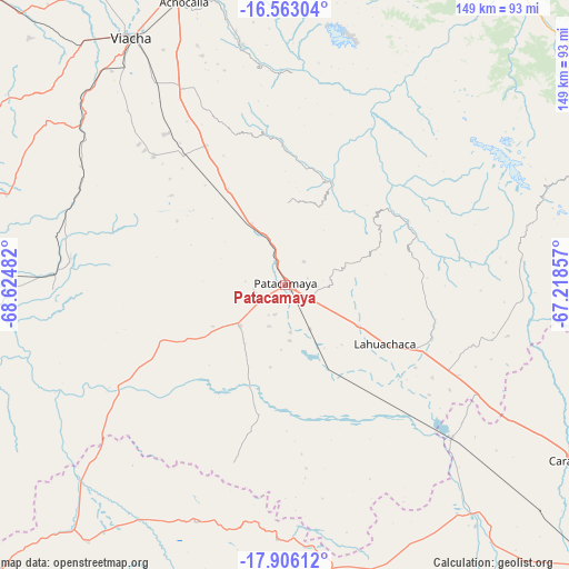
Patacamaya GPS coordinates[2]
17° 14' 8.88" South, 67° 55' 18.084" West
| Map corner | latitude | longitude |
|---|---|---|
| Upper-left | -16.56304°, | -68.62482° |
| Center: | -17.2358°, | -67.92169° |
| Lower-right: | -17.90612°, | -67.21857° |
| Map W x H: | 149.3×149.3 km | = 92.8×92.8mi |
| max Lat: | -9.71828° ⇑25.5% North |
| Patacamaya: | -17.2358° |
| min Lat: | ⇓74.5% South -22.73206° |
| min Long | Patacamaya | max Long |
| -69.14843° | -67.92169° | -57.76667° |
| W 9.9%⇐ | ⇒90.1% E |
Elevation
Elevation of Patacamaya is 3799 m = 12464 ft, and this is 1787.7 m = 5865 ft above average elevation for this country.
| Max E: |
4732 m = 15525 ft | 12.4% |
| Patacamaya | 3799 m 12464 ft | |
| Avg. | 2011.3 m = 6599 ft | |
Min E: |
92 m = 302 ft | 87.6% |
See also: Bolivia elevation on elevation.city.
Geographical zone
Patacamaya is located in South Torrid zone (between Equator and Tropic of Capricorn). Distance of this Southern Tropic circle is 689.5 km =428.4 mi to South.| Distance of | km | miles | from Patacamaya |
|---|---|---|---|
| Equator | 1916.4 | 1190.8 | to North |
| Tropic Capricorn | 689.5 | 428.4 | to South |
| Antarctic Circle | 5484.7 | 3408 | to South |
| South Pole | 8090.6 | 5027.3 | to South |


Nearby cities:
15 places around Patacamaya: (largest is in red/bold)
• Batallas
122.7 km =76.2 mi,  327°
327°
• Belen
42.1 km =26.2 mi,  110°
110°
• Chulumani
101 km =62.8 mi,  24°
24°
• Colquiri
86.1 km =53.5 mi,  101°
101°
• Coripata
109.5 km =68 mi, 18°
• Coroico
117.6 km =73.1 mi,  9°
9°
• Curahuara de Carangas
88.7 km =55.1 mi,  217°
217°
• Eucaliptus
57.8 km =35.9 mi,  131°
131°
• Independencia
118.5 km =73.6 mi,  81°
81°
• La Paz
85.3 km =53 mi,  343°
343°
• Lahuachaca
30.2 km =18.8 mi,  119°
119°
• Oruro
116.6 km =72.5 mi,  135°
135°
• Quime
80 km =49.7 mi,  69°
69°
• Tiahuanaco
110.8 km =68.8 mi,  313°
313°
• Viloco
50.7 km =31.5 mi,  51°
51°
Sources, notices
• [Note1] Compared only with cities in Bolivia existing in our database
• [Src1] Map data: © OpenStreetMap contributors (CC-BY-SA)
• [Src2] Other city data from geonames.org with taken over terms of usage.
• [Src3] Geographical zone / Annual Mean Temperature by Robert A. Rohde @ Wikipedia
