Viloco geodata
Viloco (La Paz) is a populated place; located in Bolivia in America/La_Paz (GMT-4) time zone. With population of 1,900 people, there are 106 cities with bigger population in this country. Compared to other cities in Bolivia, 78.9% of cities are located further ↓South; 87% of cities are located further →East and 86.3% of cities have lower elevation than Viloco. Note1


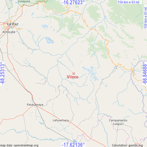
Viloco GPS coordinates[2]
16° 57' 0" South, 67° 33' 0" West
| Map corner | latitude | longitude |
|---|---|---|
| Upper-left | -16.27623°, | -68.25313° |
| Center: | -16.95°, | -67.55° |
| Lower-right: | -17.62136°, | -66.84688° |
| Map W x H: | 149.6×149.6 km | = 93×93mi |
| max Lat: | -9.71828° ⇑21.1% North |
| Viloco: | -16.95° |
| min Lat: | ⇓78.9% South -22.73206° |
| min Long | Viloco | max Long |
| -69.14843° | -67.55° | -57.76667° |
| W 13%⇐ | ⇒87% E |
Elevation
Elevation of Viloco is 3761 m = 12339 ft, and this is 1749.7 m = 5740 ft above average elevation for this country.
| Max E: |
4732 m = 15525 ft | 13.7% |
| Viloco | 3761 m 12339 ft | |
| Avg. | 2011.3 m = 6599 ft | |
Min E: |
92 m = 302 ft | 86.3% |
See also: Bolivia elevation on elevation.city.
Geographical zone
Viloco is located in South Torrid zone (between Equator and Tropic of Capricorn). Distance of this Southern Tropic circle is 721.3 km =448.2 mi to South.| Distance of | km | miles | from Viloco |
|---|---|---|---|
| Equator | 1884.7 | 1171.1 | to North |
| Tropic Capricorn | 721.3 | 448.2 | to South |
| Antarctic Circle | 5516.5 | 3427.8 | to South |
| South Pole | 8122.4 | 5047 | to South |


Nearby cities:
15 places around Viloco: (largest is in red/bold)
• Batallas
127.3 km =79.1 mi,  304°
304°
• Belen
46.3 km =28.8 mi,  180°
180°
• Chulumani
60.2 km =37.4 mi,  2°
2°
• Colchani
97.5 km =60.6 mi,  114°
114°
• Colquiri
66.4 km =41.3 mi,  137°
137°
• Coripata
72.5 km =45 mi,  355°
355°
• Coroico
86.2 km =53.6 mi,  347°
347°
• Eucaliptus
70.5 km =43.8 mi, 177°
• Independencia
79.2 km =49.2 mi,  100°
100°
• La Paz
81.2 km =50.5 mi,  308°
308°
• Lahuachaca
48.6 km =30.2 mi,  195°
195°
• Oruro
122.5 km =76.1 mi,  159°
159°
• Patacamaya
50.7 km =31.5 mi,  231°
231°
• Quime
35.6 km =22.1 mi, 95°
• Tiahuanaco
128.1 km =79.6 mi,  290°
290°
Sources, notices
• [Note1] Compared only with cities in Bolivia existing in our database
• [Src1] Map data: © OpenStreetMap contributors (CC-BY-SA)
• [Src2] Other city data from geonames.org with taken over terms of usage.
• [Src3] Geographical zone / Annual Mean Temperature by Robert A. Rohde @ Wikipedia
