Achacachi geodata
Achacachi (La Paz) is a populated place; located in Bolivia in America/La_Paz (GMT-4) time zone. With population of 8,447 people, there are 45 cities with bigger population in this country. Compared to other cities in Bolivia, 87.6% of cities are located further ↓South; 96.9% of cities are located further →East and 88.8% of cities have lower elevation than Achacachi. Note1


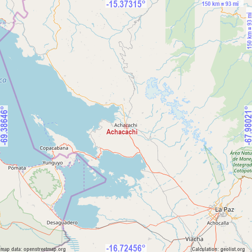
Achacachi GPS coordinates[2]
16° 3' 0" South, 68° 40' 59.988" West
| Map corner | latitude | longitude |
|---|---|---|
| Upper-left | -15.37315°, | -69.38646° |
| Center: | -16.05°, | -68.68333° |
| Lower-right: | -16.72456°, | -67.98021° |
| Map W x H: | 150.3×150.3 km | = 93.4×93.4mi |
| max Lat: | -9.71828° ⇑12.4% North |
| Achacachi: | -16.05° |
| min Lat: | ⇓87.6% South -22.73206° |
| min Long | Achacachi | max Long |
| -69.14843° | -68.68333° | -57.76667° |
| W 3.1%⇐ | ⇒96.9% E |
Elevation
Elevation of Achacachi is 3838 m = 12592 ft, and this is 1826.7 m = 5993 ft above average elevation for this country.
| Max E: |
4732 m = 15525 ft | 11.2% |
| Achacachi | 3838 m 12592 ft | |
| Avg. | 2011.3 m = 6599 ft | |
Min E: |
92 m = 302 ft | 88.8% |
See also: Bolivia elevation on elevation.city.
Geographical zone
Achacachi is located in South Torrid zone (between Equator and Tropic of Capricorn). Distance of this Southern Tropic circle is 821.3 km =510.3 mi to South.| Distance of | km | miles | from Achacachi |
|---|---|---|---|
| Equator | 1784.6 | 1108.9 | to North |
| Tropic Capricorn | 821.3 | 510.3 | to South |
| Antarctic Circle | 5616.6 | 3490 | to South |
| South Pole | 8222.5 | 5109.2 | to South |


Nearby cities:
15 places around Achacachi: (largest is in red/bold)
• Amarete
96 km =59.7 mi,  340°
340°
• Batallas
32.1 km =19.9 mi,  150°
150°
• Chulumani
129.5 km =80.5 mi,  107°
107°
• Coripata
119 km =73.9 mi,  103°
103°
• Coroico
103.1 km =64.1 mi, 98°
• Guanay
105.4 km =65.5 mi,  54°
54°
• Huarina
17.5 km =10.9 mi,  162°
162°
• Huatajata
16.7 km =10.4 mi,  180°
180°
• La Paz
75.8 km =47.1 mi,  131°
131°
• Mapiri
104.7 km =65.1 mi,  31°
31°
• San Pablo
24.5 km =15.2 mi,  220°
220°
• San Pedro
27.4 km =17 mi, 220°
• Sorata
31 km =19.3 mi,  6°
6°
• Tiahuanaco
55.8 km =34.7 mi, 179°
• Yumani
49.7 km =30.9 mi,  271°
271°
Sources, notices
• [Note1] Compared only with cities in Bolivia existing in our database
• [Src1] Map data: © OpenStreetMap contributors (CC-BY-SA)
• [Src2] Other city data from geonames.org with taken over terms of usage.
• [Src3] Geographical zone / Annual Mean Temperature by Robert A. Rohde @ Wikipedia
