Coroico geodata
Coroico (La Paz) is a seat of a third-order administrative division; located in Bolivia in America/La_Paz (GMT-4) time zone. With population of 2,361 people, there are 100 cities with bigger population in this country. Compared to other cities in Bolivia, 87% of cities are located further ↓South; 88.8% of cities are located further →East and 60.2% of cities have higher elevation than Coroico. Note1


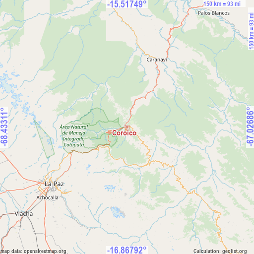
Coroico GPS coordinates[2]
16° 11' 37.896" South, 67° 43' 47.928" West
| Map corner | latitude | longitude |
|---|---|---|
| Upper-left | -15.51749°, | -68.43311° |
| Center: | -16.19386°, | -67.72998° |
| Lower-right: | -16.86792°, | -67.02686° |
| Map W x H: | 150.2×150.2 km | = 93.3×93.3mi |
| max Lat: | -9.71828° ⇑13% North |
| Coroico: | -16.19386° |
| min Lat: | ⇓87% South -22.73206° |
| min Long | Coroico | max Long |
| -69.14843° | -67.72998° | -57.76667° |
| W 11.2%⇐ | ⇒88.8% E |
Elevation
Elevation of Coroico is 1575 m = 5167 ft, and this is 436.3 m = 1431 ft below average elevation for this country.
| Max E: |
4732 m = 15525 ft | 60.2% |
| Avg. | 2011.3 m = 6599 ft | |
| Coroico | 1575 m = 5167 ft | |
Min E: |
92 m = 302 ft | 39.8% |
See also: Bolivia elevation on elevation.city.
Geographical zone
Coroico is located in South Torrid zone (between Equator and Tropic of Capricorn). Distance of this Southern Tropic circle is 805.3 km =500.4 mi to South.| Distance of | km | miles | from Coroico |
|---|---|---|---|
| Equator | 1800.6 | 1118.8 | to North |
| Tropic Capricorn | 805.3 | 500.4 | to South |
| Antarctic Circle | 5600.6 | 3480.1 | to South |
| South Pole | 8206.5 | 5099.3 | to South |


Nearby cities:
15 places around Coroico: (largest is in red/bold)
• Achacachi
103.1 km =64.1 mi,  278°
278°
• Batallas
86.6 km =53.8 mi,  262°
262°
• Chulumani
32.1 km =19.9 mi,  138°
138°
• Coripata
18.2 km =11.3 mi,  130°
130°
• Guanay
79.1 km =49.2 mi,  348°
348°
• Huarina
96.5 km =60 mi,  269°
269°
• Huatajata
101.8 km =63.3 mi, 269°
• La Paz
56.3 km =35 mi,  232°
232°
• Mapiri
114.9 km =71.4 mi,  335°
335°
• Patacamaya
117.6 km =73.1 mi,  189°
189°
• Quime
103.4 km =64.2 mi,  148°
148°
• San Pablo
117.8 km =73.2 mi, 268°
• Sorata
108.9 km =67.7 mi,  295°
295°
• Tiahuanaco
108.9 km =67.7 mi,  248°
248°
• Viloco
86.2 km =53.6 mi,  167°
167°
Sources, notices
• [Note1] Compared only with cities in Bolivia existing in our database
• [Src1] Map data: © OpenStreetMap contributors (CC-BY-SA)
• [Src2] Other city data from geonames.org with taken over terms of usage.
• [Src3] Geographical zone / Annual Mean Temperature by Robert A. Rohde @ Wikipedia
