Huatajata geodata
Huatajata (La Paz) is a populated place; located in Bolivia in America/La_Paz (GMT-4) time zone. With population of 3,700 people, there are 75 cities with bigger population in this country. Compared to other cities in Bolivia, 85.7% of cities are located further ↓South; 96.9% of cities are located further →East and 95% of cities have lower elevation than Huatajata. Note1


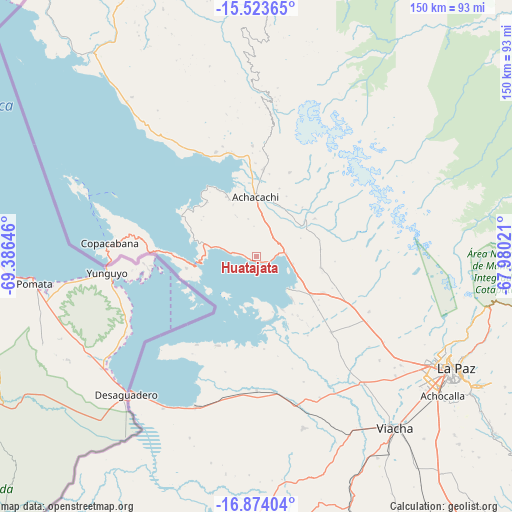
Huatajata GPS coordinates[2]
16° 12' 0" South, 68° 40' 59.988" West
| Map corner | latitude | longitude |
|---|---|---|
| Upper-left | -15.52365°, | -69.38646° |
| Center: | -16.2°, | -68.68333° |
| Lower-right: | -16.87404°, | -67.98021° |
| Map W x H: | 150.1×150.2 km | = 93.3×93.3mi |
| max Lat: | -9.71828° ⇑14.3% North |
| Huatajata: | -16.2° |
| min Lat: | ⇓85.7% South -22.73206° |
| min Long | Huatajata | max Long |
| -69.14843° | -68.68333° | -57.76667° |
| W 3.1%⇐ | ⇒96.9% E |
Elevation
Elevation of Huatajata is 3943 m = 12936 ft, and this is 1931.7 m = 6338 ft above average elevation for this country.
| Max E: |
4732 m = 15525 ft | 5% |
| Huatajata | 3943 m 12936 ft | |
| Avg. | 2011.3 m = 6599 ft | |
Min E: |
92 m = 302 ft | 95% |
See also: Bolivia elevation on elevation.city.
Geographical zone
Huatajata is located in South Torrid zone (between Equator and Tropic of Capricorn). Distance of this Southern Tropic circle is 804.6 km =500 mi to South.| Distance of | km | miles | from Huatajata |
|---|---|---|---|
| Equator | 1801.3 | 1119.3 | to North |
| Tropic Capricorn | 804.6 | 500 | to South |
| Antarctic Circle | 5599.9 | 3479.6 | to South |
| South Pole | 8205.8 | 5098.8 | to South |


Nearby cities:
15 places around Huatajata: (largest is in red/bold)
• Achacachi
16.7 km =10.4 mi,  0°
0°
• Amarete
111.9 km =69.5 mi,  343°
343°
• Batallas
19.5 km =12.1 mi,  124°
124°
• Chulumani
125.3 km =77.9 mi,  100°
100°
• Coripata
116.2 km =72.2 mi, 95°
• Coroico
101.8 km =63.3 mi,  89°
89°
• Guanay
115.9 km =72 mi,  47°
47°
• Huarina
5.3 km =3.3 mi, 90°
• La Paz
66 km =41 mi, 120°
• Mapiri
119.2 km =74.1 mi,  27°
27°
• San Pablo
16.1 km =10 mi,  263°
263°
• San Pedro
18.3 km =11.4 mi, 256°
• Sorata
47.6 km =29.6 mi, 4°
• Tiahuanaco
39.2 km =24.4 mi,  179°
179°
• Yumani
52.9 km =32.9 mi,  290°
290°
Sources, notices
• [Note1] Compared only with cities in Bolivia existing in our database
• [Src1] Map data: © OpenStreetMap contributors (CC-BY-SA)
• [Src2] Other city data from geonames.org with taken over terms of usage.
• [Src3] Geographical zone / Annual Mean Temperature by Robert A. Rohde @ Wikipedia
