Sorata geodata
Sorata (La Paz) is a populated place; located in Bolivia in America/La_Paz (GMT-4) time zone. With population of 2,190 people, there are 103 cities with bigger population in this country. Compared to other cities in Bolivia, 89.4% of cities are located further ↓South; 95% of cities are located further →East and 59.6% of cities have lower elevation than Sorata. Note1


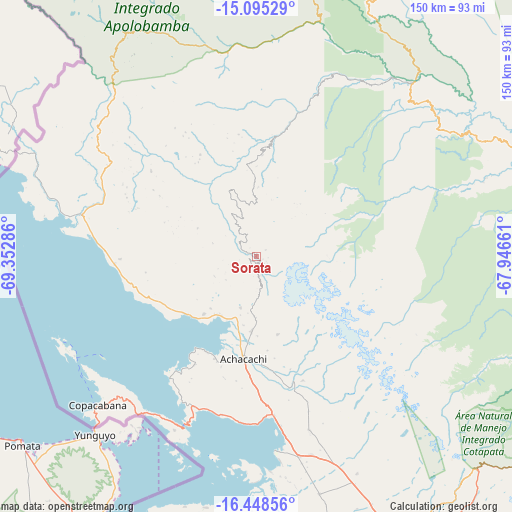
Sorata GPS coordinates[2]
15° 46' 22.98" South, 68° 38' 59.028" West
| Map corner | latitude | longitude |
|---|---|---|
| Upper-left | -15.09529°, | -69.35286° |
| Center: | -15.77305°, | -68.64973° |
| Lower-right: | -16.44856°, | -67.94661° |
| Map W x H: | 150.5×150.5 km | = 93.5×93.5mi |
| max Lat: | -9.71828° ⇑10.6% North |
| Sorata: | -15.77305° |
| min Lat: | ⇓89.4% South -22.73206° |
| min Long | Sorata | max Long |
| -69.14843° | -68.64973° | -57.76667° |
| W 5%⇐ | ⇒95% E |
Elevation
Elevation of Sorata is 2697 m = 8848 ft, and this is 685.7 m = 2250 ft above average elevation for this country.
| Max E: |
4732 m = 15525 ft | 40.4% |
| Sorata | 2697 m 8848 ft | |
| Avg. | 2011.3 m = 6599 ft | |
Min E: |
92 m = 302 ft | 59.6% |
See also: Bolivia elevation on elevation.city.
Geographical zone
Sorata is located in South Torrid zone (between Equator and Tropic of Capricorn). Distance of this Southern Tropic circle is 852.1 km =529.5 mi to South.| Distance of | km | miles | from Sorata |
|---|---|---|---|
| Equator | 1753.8 | 1089.8 | to North |
| Tropic Capricorn | 852.1 | 529.5 | to South |
| Antarctic Circle | 5647.4 | 3509.1 | to South |
| South Pole | 8253.3 | 5128.4 | to South |


Nearby cities:
15 places around Sorata: (largest is in red/bold)
• Achacachi
31 km =19.3 mi,  186°
186°
• Amarete
69.6 km =43.2 mi,  328°
328°
• Batallas
59.9 km =37.2 mi,  168°
168°
• Chulumani
139 km =86.4 mi,  120°
120°
• Coripata
126.6 km =78.7 mi, 117°
• Coroico
108.9 km =67.7 mi, 115°
• Guanay
87.6 km =54.4 mi,  69°
69°
• Huarina
47.5 km =29.5 mi,  177°
177°
• Huatajata
47.6 km =29.6 mi, 184°
• La Paz
96.9 km =60.2 mi,  146°
146°
• Mapiri
77.9 km =48.4 mi,  41°
41°
• San Pablo
53.1 km =33 mi,  201°
201°
• San Pedro
55.9 km =34.7 mi, 202°
• Tiahuanaco
86.7 km =53.9 mi, 182°
• Yumani
60.8 km =37.8 mi,  241°
241°
Sources, notices
• [Note1] Compared only with cities in Bolivia existing in our database
• [Src1] Map data: © OpenStreetMap contributors (CC-BY-SA)
• [Src2] Other city data from geonames.org with taken over terms of usage.
• [Src3] Geographical zone / Annual Mean Temperature by Robert A. Rohde @ Wikipedia
