Chulumani geodata
Chulumani (La Paz) is a populated place; located in Bolivia in America/La_Paz (GMT-4) time zone. With population of 2,952 people, there are 87 cities with bigger population in this country. Compared to other cities in Bolivia, 81.4% of cities are located further ↓South; 85.7% of cities are located further →East and 56.5% of cities have higher elevation than Chulumani. Note1


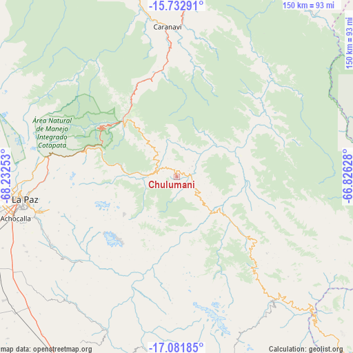
Chulumani GPS coordinates[2]
16° 24' 30.78" South, 67° 31' 45.84" West
| Map corner | latitude | longitude |
|---|---|---|
| Upper-left | -15.73291°, | -68.23253° |
| Center: | -16.40855°, | -67.5294° |
| Lower-right: | -17.08185°, | -66.82628° |
| Map W x H: | 150×150 km | = 93.2×93.2mi |
| max Lat: | -9.71828° ⇑18.6% North |
| Chulumani: | -16.40855° |
| min Lat: | ⇓81.4% South -22.73206° |
| min Long | Chulumani | max Long |
| -69.14843° | -67.5294° | -57.76667° |
| W 14.3%⇐ | ⇒85.7% E |
Elevation
Elevation of Chulumani is 1871 m = 6138 ft, and this is 140.3 m = 460 ft below average elevation for this country.
| Max E: |
4732 m = 15525 ft | 56.5% |
| Avg. | 2011.3 m = 6599 ft | |
| Chulumani | 1871 m = 6138 ft | |
Min E: |
92 m = 302 ft | 43.5% |
See also: Bolivia elevation on elevation.city.
Geographical zone
Chulumani is located in South Torrid zone (between Equator and Tropic of Capricorn). Distance of this Southern Tropic circle is 781.5 km =485.6 mi to South.| Distance of | km | miles | from Chulumani |
|---|---|---|---|
| Equator | 1824.5 | 1133.7 | to North |
| Tropic Capricorn | 781.5 | 485.6 | to South |
| Antarctic Circle | 5576.7 | 3465.2 | to South |
| South Pole | 8182.6 | 5084.4 | to South |


Nearby cities:
15 places around Chulumani: (largest is in red/bold)
• Batallas
107.8 km =67 mi,  276°
276°
• Belen
106.6 km =66.2 mi,  181°
181°
• Colquiri
117.2 km =72.8 mi,  158°
158°
• Coripata
14.2 km =8.8 mi,  328°
328°
• Coroico
32.1 km =19.9 mi,  318°
318°
• Guanay
108.1 km =67.2 mi,  339°
339°
• Huarina
120.1 km =74.6 mi, 281°
• Huatajata
125.3 km =77.9 mi, 280°
• Independencia
106.7 km =66.3 mi,  134°
134°
• La Paz
67 km =41.6 mi,  261°
261°
• Lahuachaca
108.1 km =67.2 mi,  188°
188°
• Patacamaya
101 km =62.8 mi,  204°
204°
• Quime
72.1 km =44.8 mi,  152°
152°
• Tiahuanaco
123.7 km =76.9 mi, 262°
• Viloco
60.2 km =37.4 mi, 182°
Sources, notices
• [Note1] Compared only with cities in Bolivia existing in our database
• [Src1] Map data: © OpenStreetMap contributors (CC-BY-SA)
• [Src2] Other city data from geonames.org with taken over terms of usage.
• [Src3] Geographical zone / Annual Mean Temperature by Robert A. Rohde @ Wikipedia
