Yumani geodata
Yumani (La Paz) is a populated place; located in Bolivia in America/La_Paz (GMT-4) time zone. With population of 2,500 people, there are 93 cities with bigger population in this country. Compared to other cities in Bolivia, 88.2% of cities are located further ↓South; 100% of cities are located further →East and 97.5% of cities have lower elevation than Yumani. Note1


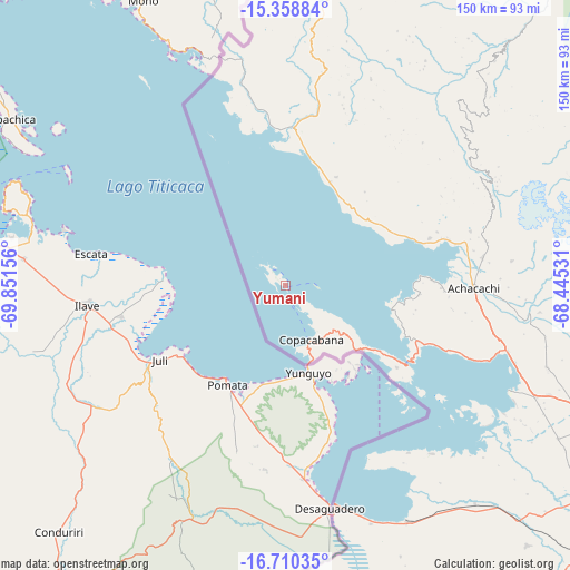
Yumani GPS coordinates[2]
16° 2' 8.664" South, 69° 8' 54.348" West
| Map corner | latitude | longitude |
|---|---|---|
| Upper-left | -15.35884°, | -69.85156° |
| Center: | -16.03574°, | -69.14843° |
| Lower-right: | -16.71035°, | -68.44531° |
| Map W x H: | 150.3×150.3 km | = 93.4×93.4mi |
| max Lat: | -9.71828° ⇑11.8% North |
| Yumani: | -16.03574° |
| min Lat: | ⇓88.2% South -22.73206° |
| min Long | Yumani | max Long |
| -69.14843° | -69.14843° | -57.76667° |
| W 0%⇐ | ⇒100% E |
Elevation
Elevation of Yumani is 3972 m = 13031 ft, and this is 1960.7 m = 6433 ft above average elevation for this country.
| Max E: |
4732 m = 15525 ft | 2.5% |
| Yumani | 3972 m 13031 ft | |
| Avg. | 2011.3 m = 6599 ft | |
Min E: |
92 m = 302 ft | 97.5% |
See also: Bolivia elevation on elevation.city.
Geographical zone
Yumani is located in South Torrid zone (between Equator and Tropic of Capricorn). Distance of this Southern Tropic circle is 822.9 km =511.3 mi to South.| Distance of | km | miles | from Yumani |
|---|---|---|---|
| Equator | 1783 | 1107.9 | to North |
| Tropic Capricorn | 822.9 | 511.3 | to South |
| Antarctic Circle | 5618.2 | 3491 | to South |
| South Pole | 8224.1 | 5110.2 | to South |


Nearby cities:
15 places around Yumani: (largest is in red/bold)
• Achacachi
49.7 km =30.9 mi,  91°
91°
• Amarete
90.6 km =56.3 mi,  11°
11°
• Batallas
72 km =44.7 mi,  114°
114°
• Chulumani
177.8 km =110.5 mi,  103°
103°
• Coripata
167.9 km =104.3 mi, 100°
• Coroico
152.5 km =94.8 mi, 96°
• Guanay
148 km =92 mi,  66°
66°
• Huarina
58 km =36 mi, 108°
• Huatajata
52.9 km =32.9 mi, 110°
• La Paz
118.4 km =73.6 mi,  115°
115°
• Mapiri
136.7 km =84.9 mi,  50°
50°
• San Pablo
39.2 km =24.4 mi, 120°
• San Pedro
38.9 km =24.2 mi,  125°
125°
• Sorata
60.8 km =37.8 mi,  61°
61°
• Tiahuanaco
76.2 km =47.3 mi,  138°
138°
Sources, notices
• [Note1] Compared only with cities in Bolivia existing in our database
• [Src1] Map data: © OpenStreetMap contributors (CC-BY-SA)
• [Src2] Other city data from geonames.org with taken over terms of usage.
• [Src3] Geographical zone / Annual Mean Temperature by Robert A. Rohde @ Wikipedia
