Quime geodata
Quime (La Paz) is a populated place; located in Bolivia in America/La_Paz (GMT-4) time zone. With population of 2,404 people, there are 98 cities with bigger population in this country. Compared to other cities in Bolivia, 78.3% of cities are located further ↓South; 82.6% of cities are located further →East and 72.7% of cities have lower elevation than Quime. Note1


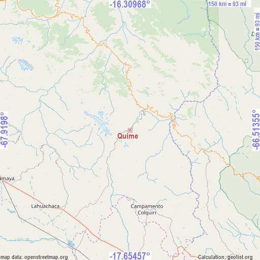
Quime GPS coordinates[2]
16° 58' 59.988" South, 67° 13' 0.012" West
| Map corner | latitude | longitude |
|---|---|---|
| Upper-left | -16.30968°, | -67.9198° |
| Center: | -16.98333°, | -67.21667° |
| Lower-right: | -17.65457°, | -66.51355° |
| Map W x H: | 149.5×149.5 km | = 92.9×92.9mi |
| max Lat: | -9.71828° ⇑21.7% North |
| Quime: | -16.98333° |
| min Lat: | ⇓78.3% South -22.73206° |
| min Long | Quime | max Long |
| -69.14843° | -67.21667° | -57.76667° |
| W 17.4%⇐ | ⇒82.6% E |
Elevation
Elevation of Quime is 3063 m = 10049 ft, and this is 1051.7 m = 3450 ft above average elevation for this country.
| Max E: |
4732 m = 15525 ft | 27.3% |
| Quime | 3063 m 10049 ft | |
| Avg. | 2011.3 m = 6599 ft | |
Min E: |
92 m = 302 ft | 72.7% |
See also: Bolivia elevation on elevation.city.
Geographical zone
Quime is located in South Torrid zone (between Equator and Tropic of Capricorn). Distance of this Southern Tropic circle is 717.5 km =445.8 mi to South.| Distance of | km | miles | from Quime |
|---|---|---|---|
| Equator | 1888.4 | 1173.4 | to North |
| Tropic Capricorn | 717.5 | 445.8 | to South |
| Antarctic Circle | 5512.8 | 3425.5 | to South |
| South Pole | 8118.7 | 5044.7 | to South |


Nearby cities:
15 places around Quime: (largest is in red/bold)
• Belen
55.4 km =34.4 mi,  219°
219°
• Chulumani
72.1 km =44.8 mi,  332°
332°
• Colchani
64.8 km =40.3 mi,  124°
124°
• Colquiri
46.1 km =28.6 mi,  168°
168°
• Coripata
86.3 km =53.6 mi, 331°
• Coroico
103.4 km =64.2 mi, 328°
• Eucaliptus
73.9 km =45.9 mi,  205°
205°
• Independencia
43.8 km =27.2 mi,  104°
104°
• La Paz
113 km =70.2 mi,  298°
298°
• Lahuachaca
65 km =40.4 mi,  228°
228°
• Oruro
111.4 km =69.2 mi,  176°
176°
• Patacamaya
80 km =49.7 mi,  249°
249°
• Quillacollo
109.6 km =68.1 mi,  114°
114°
• Sipe Sipe
102.6 km =63.8 mi, 120°
• Viloco
35.6 km =22.1 mi,  275°
275°
Sources, notices
• [Note1] Compared only with cities in Bolivia existing in our database
• [Src1] Map data: © OpenStreetMap contributors (CC-BY-SA)
• [Src2] Other city data from geonames.org with taken over terms of usage.
• [Src3] Geographical zone / Annual Mean Temperature by Robert A. Rohde @ Wikipedia
