Coromandel geodata
Coromandel (Minas Gerais) is a populated place; located in Brazil in America/Sao_Paulo (GMT-3) time zone. With population of 22,647 people, there are 845 cities with bigger population in this country. Compared to other cities in Brazil, 51.7% of cities are located further ↑North; 59.8% of cities are located further →East and 97.1% of cities have lower elevation than Coromandel. Note1


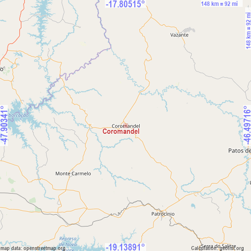
Coromandel GPS coordinates[2]
18° 28' 23.988" South, 47° 12' 1.008" West
| Map corner | latitude | longitude |
|---|---|---|
| Upper-left | -17.80515°, | -47.90341° |
| Center: | -18.47333°, | -47.20028° |
| Lower-right: | -19.13891°, | -46.49716° |
| Map W x H: | 148.3×148.3 km | = 92.1×92.1mi |
| max Lat: | 2.81972° ⇑51.7% North |
| Coromandel: | -18.47333° |
| min Lat: | ⇓48.3% South -33.69111° |
| min Long | Coromandel | max Long |
| -72.89583° | -47.20028° | -32.41083° |
| W 40.2%⇐ | ⇒59.8% E |
Elevation
Elevation of Coromandel is 941 m = 3087 ft, and this is 560.1 m = 1838 ft above average elevation for this country.
| Max E: |
1603 m = 5259 ft | 2.9% |
| Coromandel | 941 m 3087 ft | |
| Avg. | 380.9 m = 1250 ft | |
Min E: |
0 m = 0 ft | 97.1% |
See also: Brazil elevation on elevation.city.
Geographical zone
Coromandel is located in South Torrid zone (between Equator and Tropic of Capricorn). Distance of this Southern Tropic circle is 551.9 km =342.9 mi to South.| Distance of | km | miles | from Coromandel |
|---|---|---|---|
| Equator | 2054 | 1276.3 | to North |
| Tropic Capricorn | 551.9 | 342.9 | to South |
| Antarctic Circle | 5347.1 | 3322.5 | to South |
| South Pole | 7953 | 4941.8 | to South |


Nearby cities:
15 places around Coromandel: (largest is in red/bold)
• Araguari
105.8 km =65.7 mi,  259°
259°
• Araxá
127.5 km =79.2 mi,  167°
167°
• Carmo do Paranaíba
110 km =68.4 mi,  122°
122°
• Catalão
85.9 km =53.4 mi,  293°
293°
• Ibiá
131.6 km =81.8 mi,  148°
148°
• Ipameri
131.4 km =81.6 mi,  309°
309°
• João Pinheiro
135.7 km =84.3 mi,  53°
53°
• Lagoa Formosa
90.2 km =56 mi,  112°
112°
• Monte Carmelo
42.1 km =26.2 mi,  228°
228°
• Paracatu
143.3 km =89 mi,  13°
13°
• Patos de Minas
72.9 km =45.3 mi,  99°
99°
• Patrocínio
56.7 km =35.2 mi,  157°
157°
• Presidente Olegário
82.7 km =51.4 mi,  85°
85°
• Uberlândia
123.8 km =76.9 mi,  246°
246°
• Vazante
62.3 km =38.7 mi,  29°
29°
Sources, notices
• [Note1] Compared only with cities in Brazil existing in our database
• [Src1] Map data: © OpenStreetMap contributors (CC-BY-SA)
• [Src2] Other city data from geonames.org with taken over terms of usage.
• [Src3] Geographical zone / Annual Mean Temperature by Robert A. Rohde @ Wikipedia
