Poxoréo geodata
Poxoréo (Mato Grosso) is a populated place; located in Brazil in America/Cuiaba (GMT-4) time zone. With population of 12,475 people, there are 1425 cities with bigger population in this country. Compared to other cities in Brazil, 53.9% of cities are located further ↓South; 93.3% of cities are located further →East and 51% of cities have lower elevation than Poxoréo. Note1


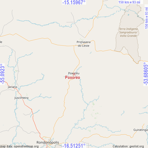
Poxoréo GPS coordinates[2]
15° 50' 13.992" South, 54° 23' 21.012" West
| Map corner | latitude | longitude |
|---|---|---|
| Upper-left | -15.15967°, | -55.0923° |
| Center: | -15.83722°, | -54.38917° |
| Lower-right: | -16.51251°, | -53.68605° |
| Map W x H: | 150.4×150.4 km | = 93.5×93.5mi |
| max Lat: | 2.81972° ⇑46.1% North |
| Poxoréo: | -15.83722° |
| min Lat: | ⇓53.9% South -33.69111° |
| min Long | Poxoréo | max Long |
| -72.89583° | -54.38917° | -32.41083° |
| W 6.7%⇐ | ⇒93.3% E |
Elevation
Elevation of Poxoréo is 364 m = 1194 ft, and this is 16.9 m = 55 ft below average elevation for this country.
| Max E: |
1603 m = 5259 ft | 49% |
| Avg. | 380.9 m = 1250 ft | |
| Poxoréo | 364 m = 1194 ft | |
Min E: |
0 m = 0 ft | 51% |
See also: Brazil elevation on elevation.city.
Geographical zone
Poxoréo is located in South Torrid zone (between Equator and Tropic of Capricorn). Distance of this Southern Tropic circle is 845 km =525.1 mi to South.| Distance of | km | miles | from Poxoréo |
|---|---|---|---|
| Equator | 1760.9 | 1094.2 | to North |
| Tropic Capricorn | 845 | 525.1 | to South |
| Antarctic Circle | 5640.2 | 3504.7 | to South |
| South Pole | 8246.1 | 5123.9 | to South |


Nearby cities:
15 places around Poxoréo: (largest is in red/bold)
• Alto Araguaia
206.5 km =128.3 mi,  142°
142°
• Aragarças
228.8 km =142.2 mi,  91°
91°
• Barra do Garças
228.2 km =141.8 mi, 91°
• Barão de Melgaço
173.3 km =107.7 mi,  256°
256°
• Chapada dos Guimarães
151.6 km =94.2 mi,  286°
286°
• Cuiabá
184.7 km =114.8 mi,  278°
278°
• Guiratinga
87.7 km =54.5 mi,  130°
130°
• Jaciara
63.5 km =39.5 mi, 257°
• Lucas
173.9 km =108.1 mi,  251°
251°
• Nobres
242.2 km =150.5 mi,  300°
300°
• Poconé
243.2 km =151.1 mi, 258°
• Rondonópolis
75.2 km =46.7 mi,  200°
200°
• Rosário Oeste
245.3 km =152.4 mi, 296°
• Santo Antônio do Leverger
180.5 km =112.2 mi,  268°
268°
• Várzea Grande
187.8 km =116.7 mi, 276°
Sources, notices
• [Note1] Compared only with cities in Brazil existing in our database
• [Src1] Map data: © OpenStreetMap contributors (CC-BY-SA)
• [Src2] Other city data from geonames.org with taken over terms of usage.
• [Src3] Geographical zone / Annual Mean Temperature by Robert A. Rohde @ Wikipedia
