Eunápolis geodata
Eunápolis (Bahia) is a populated place; located in Brazil in America/Bahia (GMT-3) time zone. With population of 114,275 people, there are 196 cities with bigger population in this country. Compared to other cities in Brazil, 52.5% of cities are located further ↓South; 76.9% of cities are located further ←West and 64.3% of cities have higher elevation than Eunápolis. Note1


Eunápolis GPS coordinates[2]
16° 22' 39" South, 39° 34' 49.008" West
| Map corner | latitude | longitude |
|---|---|---|
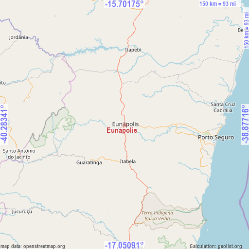
| Upper-left | -15.70175°, | -40.28341° |
| Center: | -16.3775°, | -39.58028° |
| Lower-right: | -17.05091°, | -38.87716° |
| Map W x H: | 150×150 km | = 93.2×93.2mi |
| max Lat: | 2.81972° ⇑47.5% North |
| Eunápolis: | -16.3775° |
| min Lat: | ⇓52.5% South -33.69111° |
| min Long | Eunápolis | max Long |
| -72.89583° | -39.58028° | -32.41083° |
| W 76.9%⇐ | ⇒23.1% E |
Elevation
Elevation of Eunápolis is 173 m = 568 ft, and this is 207.9 m = 682 ft below average elevation for this country.
| Max E: |
1603 m = 5259 ft | 64.3% |
| Avg. | 380.9 m = 1250 ft | |
| Eunápolis | 173 m = 568 ft | |
Min E: |
0 m = 0 ft | 35.7% |
See also: Eunápolis elevation on elevation.city.
Geographical zone
Eunápolis is located in South Torrid zone (between Equator and Tropic of Capricorn). Distance of this Southern Tropic circle is 784.9 km =487.7 mi to South.| Distance of | km | miles | from Eunápolis |
|---|---|---|---|
| Equator | 1821 | 1131.5 | to North |
| Tropic Capricorn | 784.9 | 487.7 | to South |
| Antarctic Circle | 5580.2 | 3467.4 | to South |
| South Pole | 8186.1 | 5086.6 | to South |


Nearby cities:
15 places around Eunápolis: (largest is in red/bold)
• Almenara
120.9 km =75.1 mi,  280°
280°
• Belmonte
94.3 km =58.6 mi,  52°
52°
• Canavieiras
103.3 km =64.2 mi,  40°
40°
• Guaratinga
31.6 km =19.6 mi,  222°
222°
• Itamaraju
73.8 km =45.9 mi,  175°
175°
• Itanhém
118.6 km =73.7 mi, 222°
• Itarantim
95.2 km =59.2 mi,  326°
326°
• Mascote
95.3 km =59.2 mi,  18°
18°
• Medeiros Neto
130.1 km =80.8 mi,  211°
211°
• Pau Brasil
101.8 km =63.3 mi,  355°
355°
• Porto Seguro
55.6 km =34.5 mi,  98°
98°
• Prado
113.8 km =70.7 mi,  160°
160°
• Santa Cruz Cabrália
60.3 km =37.5 mi,  79°
79°
• Teixeira de Freitas
129.8 km =80.7 mi,  187°
187°
• Una
132.1 km =82.1 mi, 24°
Sources, notices
• [Note1] Compared only with cities in Brazil existing in our database
• [Src1] Map data: © OpenStreetMap contributors (CC-BY-SA)
• [Src2] Other city data from geonames.org with taken over terms of usage.
• [Src3] Geographical zone / Annual Mean Temperature by Robert A. Rohde @ Wikipedia
