Guaratinga geodata
Guaratinga (Bahia) is a populated place; located in Brazil in America/Bahia (GMT-3) time zone. With population of 9,519 people, there are 1688 cities with bigger population in this country. Compared to other cities in Brazil, 51.8% of cities are located further ↓South; 76.1% of cities are located further ←West and 64.4% of cities have higher elevation than Guaratinga. Note1


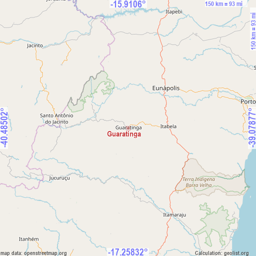
Guaratinga GPS coordinates[2]
16° 35' 8.304" South, 39° 46' 54.804" West
| Map corner | latitude | longitude |
|---|---|---|
| Upper-left | -15.9106°, | -40.48502° |
| Center: | -16.58564°, | -39.78189° |
| Lower-right: | -17.25832°, | -39.07877° |
| Map W x H: | 149.9×149.9 km | = 93.1×93.1mi |
| max Lat: | 2.81972° ⇑48.2% North |
| Guaratinga: | -16.58564° |
| min Lat: | ⇓51.8% South -33.69111° |
| min Long | Guaratinga | max Long |
| -72.89583° | -39.78189° | -32.41083° |
| W 76.1%⇐ | ⇒23.9% E |
Elevation
Elevation of Guaratinga is 171 m = 561 ft, and this is 209.9 m = 689 ft below average elevation for this country.
| Max E: |
1603 m = 5259 ft | 64.4% |
| Avg. | 380.9 m = 1250 ft | |
| Guaratinga | 171 m = 561 ft | |
Min E: |
0 m = 0 ft | 35.6% |
See also: Brazil elevation on elevation.city.
Geographical zone
Guaratinga is located in South Torrid zone (between Equator and Tropic of Capricorn). Distance of this Southern Tropic circle is 761.8 km =473.4 mi to South.| Distance of | km | miles | from Guaratinga |
|---|---|---|---|
| Equator | 1844.2 | 1145.9 | to North |
| Tropic Capricorn | 761.8 | 473.4 | to South |
| Antarctic Circle | 5557 | 3453 | to South |
| South Pole | 8162.9 | 5072.2 | to South |


Nearby cities:
15 places around Guaratinga: (largest is in red/bold)
• Almenara
107.1 km =66.5 mi,  294°
294°
• Belmonte
125.5 km =78 mi,  50°
50°
• Eunápolis
31.6 km =19.6 mi,  42°
42°
• Itamaraju
57.1 km =35.5 mi,  152°
152°
• Itanhém
87 km =54.1 mi,  222°
222°
• Itarantim
107.3 km =66.7 mi,  343°
343°
• Jequitinhonha
131.3 km =81.6 mi,  277°
277°
• Joaíma
133.3 km =82.8 mi,  266°
266°
• Mascote
124.7 km =77.5 mi,  24°
24°
• Medeiros Neto
99.3 km =61.7 mi,  208°
208°
• Pau Brasil
125.5 km =78 mi,  6°
6°
• Porto Seguro
77.9 km =48.4 mi,  78°
78°
• Prado
103 km =64 mi,  144°
144°
• Santa Cruz Cabrália
87.7 km =54.5 mi,  67°
67°
• Teixeira de Freitas
105.6 km =65.6 mi,  177°
177°
Sources, notices
• [Note1] Compared only with cities in Brazil existing in our database
• [Src1] Map data: © OpenStreetMap contributors (CC-BY-SA)
• [Src2] Other city data from geonames.org with taken over terms of usage.
• [Src3] Geographical zone / Annual Mean Temperature by Robert A. Rohde @ Wikipedia
