Porto Seguro geodata
Porto Seguro (Bahia) is a populated place; located in Brazil in America/Bahia (GMT-3) time zone. With population of 123,173 people, there are 182 cities with bigger population in this country. Compared to other cities in Brazil, 52.2% of cities are located further ↓South; 79.7% of cities are located further ←West and 99.3% of cities have higher elevation than Porto Seguro. Note1


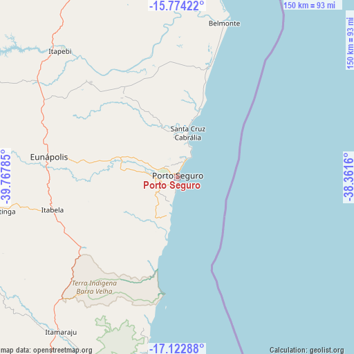
Porto Seguro GPS coordinates[2]
16° 26' 58.992" South, 39° 3' 52.992" West
| Map corner | latitude | longitude |
|---|---|---|
| Upper-left | -15.77422°, | -39.76785° |
| Center: | -16.44972°, | -39.06472° |
| Lower-right: | -17.12288°, | -38.3616° |
| Map W x H: | 150×150 km | = 93.2×93.2mi |
| max Lat: | 2.81972° ⇑47.8% North |
| Porto Seguro: | -16.44972° |
| min Lat: | ⇓52.2% South -33.69111° |
| min Long | Porto Seguro | max Long |
| -72.89583° | -39.06472° | -32.41083° |
| W 79.7%⇐ | ⇒20.3% E |
Elevation
Elevation of Porto Seguro is 4 m = 13 ft, and this is 376.9 m = 1237 ft below average elevation for this country.
| Max E: |
1603 m = 5259 ft | 99.3% |
| Avg. | 380.9 m = 1250 ft | |
| Porto Seguro | 4 m = 13 ft | |
Min E: |
0 m = 0 ft | 0.7% |
See also: Porto Seguro elevation on elevation.city.
Geographical zone
Porto Seguro is located in South Torrid zone (between Equator and Tropic of Capricorn). Distance of this Southern Tropic circle is 776.9 km =482.7 mi to South.| Distance of | km | miles | from Porto Seguro |
|---|---|---|---|
| Equator | 1829 | 1136.5 | to North |
| Tropic Capricorn | 776.9 | 482.7 | to South |
| Antarctic Circle | 5572.1 | 3462.3 | to South |
| South Pole | 8178 | 5081.6 | to South |


Nearby cities:
15 places around Porto Seguro: (largest is in red/bold)
• Belmonte
68.3 km =42.4 mi,  16°
16°
• Canavieiras
87.1 km =54.1 mi,  8°
8°
• Eunápolis
55.6 km =34.5 mi,  278°
278°
• Guaratinga
77.9 km =48.4 mi,  258°
258°
• Itamaraju
82.2 km =51.1 mi,  217°
217°
• Itanhém
156.5 km =97.2 mi,  239°
239°
• Itarantim
138.4 km =86 mi,  309°
309°
• Mascote
101.8 km =63.3 mi,  345°
345°
• Medeiros Neto
160.2 km =99.5 mi,  230°
230°
• Nova Viçosa
163.6 km =101.7 mi,  191°
191°
• Pau Brasil
126.2 km =78.4 mi,  330°
330°
• Prado
100.5 km =62.4 mi, 189°
• Santa Cruz Cabrália
19.6 km =12.2 mi, 12°
• Teixeira de Freitas
140.5 km =87.3 mi,  210°
210°
• Una
128.6 km =79.9 mi,  359°
359°
Sources, notices
• [Note1] Compared only with cities in Brazil existing in our database
• [Src1] Map data: © OpenStreetMap contributors (CC-BY-SA)
• [Src2] Other city data from geonames.org with taken over terms of usage.
• [Src3] Geographical zone / Annual Mean Temperature by Robert A. Rohde @ Wikipedia
