Lagoa Formosa geodata
Lagoa Formosa (Minas Gerais) is a populated place; located in Brazil in America/Sao_Paulo (GMT-3) time zone. With population of 11,822 people, there are 1495 cities with bigger population in this country. Compared to other cities in Brazil, 52.8% of cities are located further ↑North; 54.4% of cities are located further →East and 93.9% of cities have lower elevation than Lagoa Formosa. Note1


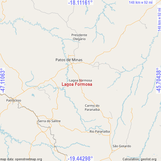
Lagoa Formosa GPS coordinates[2]
18° 46' 42.996" South, 46° 24' 27" West
| Map corner | latitude | longitude |
|---|---|---|
| Upper-left | -18.11161°, | -47.11063° |
| Center: | -18.77861°, | -46.4075° |
| Lower-right: | -19.44298°, | -45.70438° |
| Map W x H: | 148×148 km | = 92×92mi |
| max Lat: | 2.81972° ⇑52.8% North |
| Lagoa Formosa: | -18.77861° |
| min Lat: | ⇓47.2% South -33.69111° |
| min Long | Lagoa Formosa | max Long |
| -72.89583° | -46.4075° | -32.41083° |
| W 45.6%⇐ | ⇒54.4% E |
Elevation
Elevation of Lagoa Formosa is 878 m = 2881 ft, and this is 497.1 m = 1631 ft above average elevation for this country.
| Max E: |
1603 m = 5259 ft | 6.1% |
| Lagoa Formosa | 878 m 2881 ft | |
| Avg. | 380.9 m = 1250 ft | |
Min E: |
0 m = 0 ft | 93.9% |
See also: Brazil elevation on elevation.city.
Geographical zone
Lagoa Formosa is located in South Torrid zone (between Equator and Tropic of Capricorn). Distance of this Southern Tropic circle is 517.9 km =321.8 mi to South.| Distance of | km | miles | from Lagoa Formosa |
|---|---|---|---|
| Equator | 2088 | 1297.4 | to North |
| Tropic Capricorn | 517.9 | 321.8 | to South |
| Antarctic Circle | 5313.2 | 3301.5 | to South |
| South Pole | 7919.1 | 4920.7 | to South |


Nearby cities:
15 places around Lagoa Formosa: (largest is in red/bold)
• Abaeté
109.7 km =68.2 mi,  112°
112°
• Araxá
106.5 km =66.2 mi,  211°
211°
• Campos Altos
105 km =65.2 mi,  166°
166°
• Carmo do Paranaíba
26.5 km =16.5 mi,  158°
158°
• Coromandel
90.2 km =56 mi,  292°
292°
• Dores do Indaiá
113.9 km =70.8 mi,  131°
131°
• Ibiá
79 km =49.1 mi,  190°
190°
• João Pinheiro
117.8 km =73.2 mi,  12°
12°
• Luz
136.6 km =84.9 mi,  146°
146°
• Monte Carmelo
115 km =71.5 mi,  272°
272°
• Patos de Minas
25.1 km =15.6 mi,  332°
332°
• Patrocínio
64.2 km =39.9 mi,  253°
253°
• Presidente Olegário
40.1 km =24.9 mi,  358°
358°
• São Gotardo
70.2 km =43.6 mi, 147°
• Vazante
102.6 km =63.8 mi, 329°
Sources, notices
• [Note1] Compared only with cities in Brazil existing in our database
• [Src1] Map data: © OpenStreetMap contributors (CC-BY-SA)
• [Src2] Other city data from geonames.org with taken over terms of usage.
• [Src3] Geographical zone / Annual Mean Temperature by Robert A. Rohde @ Wikipedia
